
- INTRODUCTION TO GPMP
- INTRODUCTION TO Ancient Egypt Research Associates, Inc. (AERA)
- The AERA Home Page
- ARTICLES
- ANNUAL REPORTS
- CONSTRUCTING THE GIZA PLATEAU COMPUTER MODEL (1990-1995)
- RECENT WORK ON THE GIZA PLATEAU COMPUTER MODEL (1997-1998)
- SOURCE MATERIALS FOR THE GIZA PLATEAU COMPUTER MODEL.
INTRODUCTION
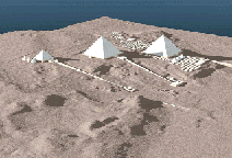
The Giza Plateau Mapping Project, under the direction of Mark Lehner, Visiting Assistant Professor of Egyptian archaeology at the Oriental Institute, is dedicated to research on the geology and topography of the Giza plateau, the construction and function of the Sphinx, the Great Pyrimids, the associated tombs and temples, and the Old Kingdom town in the vicinity. Lehner is a pioneer in the use of state-of-the-art computer graphics and remote sensing technology to model the ancient configuration of the Giza Plateau. In addition he has collaborated with an architectural firm to produce a detailed computer model of the Sphnix which is of exceptional value both as a research tool and to guide current conservation efforts.
The underlying data for the Giza Plateau model are not available to the public at this time. When the basic model is finished we will determine how and to whom the model will be made available.
Lehner is an acknowledged leader in Egyptian archaeology whose innovative and original contributions have opened a new era in Old Kingdom studies. In 1993 he was featured in two exceptionally interesting educational television productions, one in the NOVA series and another produced by the National Geographic Society.
Articles
Annual Reports
- 2014-2015 Annual Report
- 2013-2014 Annual Report
- 2011-2012 Annual Report
- 2009-2010 Annual Report
- 2008-2009 Annual Report
- 2007-2008 Annual Report
- 2005-2006 Annual Report
- 2003-2004 Annual Report
- 2002-2003 Annual Report
- 2001-2002 Annual Report
- 2000-2001 Annual Report
- 1999-2000 Annual Report
- 1998-1999 Annual Report
- 1995-1996 Annual Report
- 1993-1994 Annual Report
- 1991-1992 Annual Report
