
The small step pyramid at South Edfu is one of seven such structures from the Old Kingdom to be situated outside of the royal cemeteries (Memphis). It belongs to a group of identical constructions that have been found in close proximity to important settlement sites in Middle Egypt (at Seila and Zaweit al-Maitin) and Upper Egypt (at Sinki-Abydos, Nagada, al-Kula-Hierakonpolis, al-Ghonameya-Edfu and Elephantine). Up to now, no example for such a provincial pyramid has been found in the Nile Delta region. Without any trace of a funerary chamber or subterranean structure, it is thought that these provincial pyramids were dedicated to the worship of the pharaoh.
The Edfu pyramid is located only 5 km south of Tell Edfu, and 25 km south of the pyramid of al-Kula, which is linked to the major Predynastic site of Hierakonpolis. The pyramid is situated north of the modern village of el-Ghonameya, between the edge of the desert and the cultivated areas of the Nile Valley. Provincial pyramids, including the Edfu Pyramid, are believed to date to the beginning of the 4th dynasty, although they may date to as early as the late .
History of Research
The first reference to the Edfu Pyramid dates back to 1894 when G. Legrain, who worked on a Predynastic cemetery situated further south, indicated a 'false' pyramid at the entrance of the caravan road Edfu-Kharga. In 1908 H. de Morgan mentions the structure again and two years later A. Weigall indicates also the presence of this monument in his “Guide to the Antiquities of Upper Egypt from Abydos to the Sudan Frontier”. He recognized its shape as a step pyramid and gives its correct dimensions but in feet instead of meters, which means that he probably never visited the site himself but recovered this information from a previous description. The archaeological site is only marked on the 1928 map before it disappears again from later topographic maps. The site then remained largely unknown for decades until the chief inspector of the Edfu area, Mohamed A. Aly, showed the monument to W. Kaiser and G. Dreyer in 1979. Both included the site in their comprehensive study of the provincial pyramids complementing the previous studies conducted by J.-Ph. Lauer in 1962 and V. Maragioglio and C. Renaldi in 1963.
No methodical excavation or cleaning of the pyramid superstructure has ever been carried out before 2011 except for some holes made by looting and pillaging of stone blocks in order to use them as building material.Despite the protection by the Egyptian government the site has become more and more endangered over the past forty years and is rapidly disappearing. Since the construction of the Aswan high dam in 1964 the region of Edfu has evolved significantly, especially the occupation along the desert edge. The el-Ghonameya village stretches now more than 1.5 km further north than forty years ago and reaches today the immediate vicinity of the pyramid.
During the early 1990's the construction of a new access road to the desert highway between Cairo and Aswan has led to the destruction of the whole southern part of the archaeological site. This road lies now at 50 m from the pyramid and causes the continuous deposit of rubbish and waste on the site. A modern cemetery surrounds the northern part of the site. It has been marked on the maps since 1906, and is advancing quickly towards the archaeological area over the past 5 years as can be seen on satellite images. The recent construction of a mosque in 2005 has led to a faster development of the cemetery towards the west and the south, and the daily circulation on the site has clearly increased. In addition, a new gas pipeline will be built along the asphalt road in the next few months threatening dangerously the southern part of the site.
The Edfu Pyramid Project
These problems have encouraged us in 2009 to start a rescue excavation and conservation project in close collaboration with the local antiquities inspectorate in order to protect this last provincial pyramid. The monument at Edfu offers indeed a final opportunity to increase our knowledge about this peculiar phenomenon, to refine the dating and to verify our hypothesis concerning the potential existence of further related installations that had been built against the monument or in the surrounding area. This project is also closely connected to a new stage of the excavation program at Tell Edfu, which is focusing on the exploration of the Old Kingdom settlement remains and the origins of this town, which certainly dates back to the same time as the pyramid. The presence of a provincial pyramid south of Edfu indicates that the town already played an important role on a regional and national level at the end of Dynasty 3.
In 2010 a preliminary survey was conducted in order to establish a first contact and to mark our presence on site, as well as to evaluate the state of preservation of the superstructure. A general map was drawn in order to define and to protect more clearly the archaeological zone, now reduced to an area stretching 220 m east-west and 120 m north-south (about 6 acres). The sand accumulation and the absence of structural remains apart from the pyramid itself permitted a systematic collection of pottery fragments in the whole area to acquire more information about its precise date. Due to the presence of only few sherds on the surface, it was possible to systematically register their position with a total station. 68% of the collected surface pottery dates to the Old Kingdom. The identified shapes, mainly large storage vessels or beer jars and fine wares, clearly belong to the tradition of Dynasty 3 and the early Dynasty 4. There is no sign of any other pharaonic period activity, particularly from the Middle or the New Kingdom, an observation that underlines the limited duration of activity at this monument. The remaining 32% of sherds date exclusively to the late Coptic and early Islamic periods when the first plundering of stone material seems to have occurred.
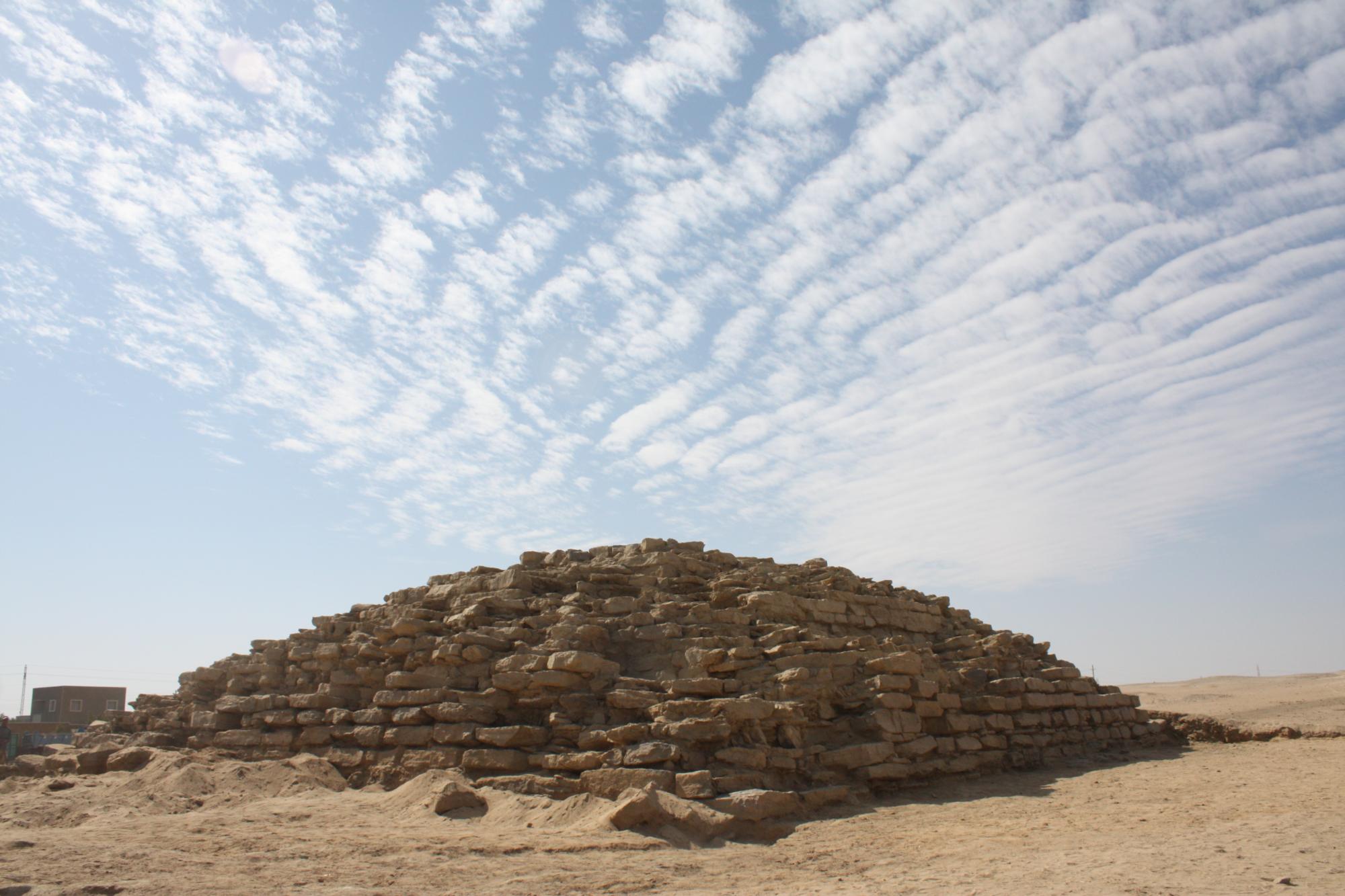
A first season of fieldwork was carried out during Fall 2011 with the help of Aurelie Schenk and a team of forty Egyptian workers from Luxor and Edfu. In less than three weeks it was possible to expose the nearly complete pyramid superstructure, which previously resembled a kind of tumulus of about 30 m in diameter being covered by a thick layer of sand, smaller stone blocks and demolition debris. Extensive cleaning was also carried out in the entire archaeological area in order to remove the modern rubbish.
The cleaning operation of the pyramid itself revealed the original appearance of the monument much to the astonishment of the locals who were ignorant of the existence of a pharaonic monument here. Indeed, during the 2010 survey, the collective memory of the local inhabitants still testified to the presence of a sheikh's tomb here, the burial of a local Muslim saint, which is a factor that has certainly contributed to the encroachment of the modern cemetery towards the pyramid. Some child burials identified along the southern and eastern faces of the monument seem also to correspond to its relatively recent assignment as a holy place. The southern and especially northern sides of the pyramid are the best-preserved areas with 6 to 7 courses of blocks still visible on the external face. The western and southern sides of the monument as well as its top have seen seven isolated attempts of pillaging, the western face is the most damaged one and the large pile of rubble on that side could not be removed completely during our first season of work.
The pyramid had been built directly on the sandstone bedrock and was made exclusively of sandstone and some calcareous sandstone blocks. The structure is orientated to the cardinal points by its faces. It was originally made of three steps, two inclined layers leaning against a central core . Its internal structure and the use of the “accretion layer” technique can be easily seen on the northern and southern faces . The central core measures 8.50 m to 8.95 m at its current level of preservation and the first layer has a length of 13.30 m to 13.70 m. Along its base the monument measures about 18.45 m to 18.50 m, which corresponds to about 35 royal cubits. Except for the case of Seila in the Fayyum Oasis (31 m in length), the other step pyramids show very similar dimensions which lie between 18.30 m (Zawiet al-Meitin), 18.40 m (Elephantine and Nagada) and 18.60 m (al-Kula and Sinki). The height reaches only 4.90 m today mainly because of the reuse of the blocks for private construction. With a length of approximately 50 cubits in the diagonal direction through the center, a simple geometrical link between triangles can be used for evaluating the original elevation of the monument, which can be estimated to have been ca. 13.00 m (25 royal cubits). This means only less than a third of it remains today.
The dismantling of the structure is difficult to date but the presence of post-7th centuries AD pottery sherds in the lowest levels of demolition suggests that the dismantling occurred in a relatively late phase of the life of the monument. Furthermore, some post-Old Kingdom hieroglyphic graffiti have been found on the northern and southern lower courses and maybe this indicates that the monument has kept its symbolic form and significance throughout a large part of the pharaonic period.
The construction itself reflects a certain care and a real expertise in the mastery of stone construction especially for the adjustment of the most important blocks. The stones had been cut roughly into shape by percussion without any further refinement, but they are all relatively similar in size with standardized dimensions of 65 cm to 80 cm in length for the upper part. In the lower part some blocks regularly exceed 1.00 m to 1.50 m in length and more than 2.00 m for some large slabs of very hard brown sandstone, which was mainly used for the external courses and for producing a solid foundation layer. The blocks are held together by a large amount of clay mortar that contains a considerable amount of river sand. 5 to 6 varieties of local sandstones can be distinguished and must have been acquired in the close vicinity of the monument. The quarry area has been discovered only 800 meters north of the site during an extensive preliminary survey conducted on some of the small hills that mark the desert edge in this area. A more systematic exploration and mapping of this extraction site will be undertaken next season in order to gain more information about the chronology, the organization of the construction work and the supply of the raw materials for the pyramid.
The most significant detail that appears this season concerns the clear evidence of an additional installation on the eastern side, maybe an offering place. The 2010 survey has revealed the largest concentration of pottery sherds here and a diagnostic trench was dug in 2011 which exposed the remains of two parallel walls surrounding a square negative left by the removal of a kind of structure which was, regular in shape measuring almost one square meter. It marks certainly the position of a totally dismantled installation and many pieces of fine white limestone (a non-local stone!) have been found in this area. This could highlight the nature of this construction that had been originally erected on the bedrock and placed against the center of the eastern face of the pyramid, which becomes under the reign of Snofru the typical location for the funerary temple attached to the traditional pyramids.
