
McGuire Gibson
Professor of Mesopotamian Archaeology
The Oriental Institute
The University of Chicago
(This article originally appeared in Nippur at the Centennial (Philadelphia, 1992), and is made available electronically with the permission of the editor.)
NOTE: THIS DOCUMENT IS IN PROCESS. THE HTML MARKUP FOR THE FOOTNOTES IS NOT YET COMPLETE. TEMPORARILY, NUMBERS INSIDE BRACKETS [] INDICATE FOOTNOTE NUMBERS
Archaeologists today routinely approach a site by first making a controlled collection of the sherds and other objects on its surface. In the case of a site that has already been worked on for many years, the excavator may carry out such a collection as a supplement to excavation, in order to gain an idea of the patterns of occupation at the site, to try to determine the functions of specific areas, or just to give an indication of where he might profitably excavate to find particular material.
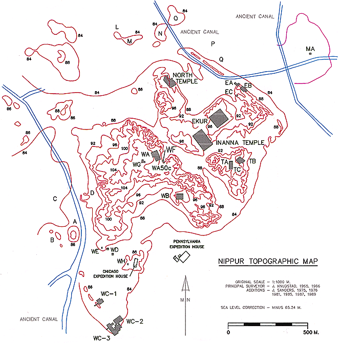
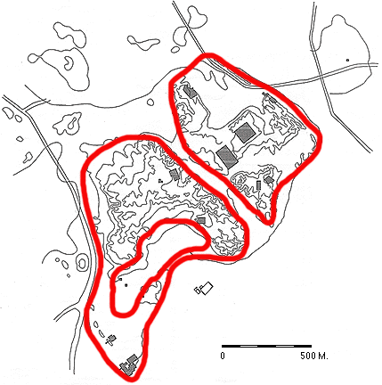
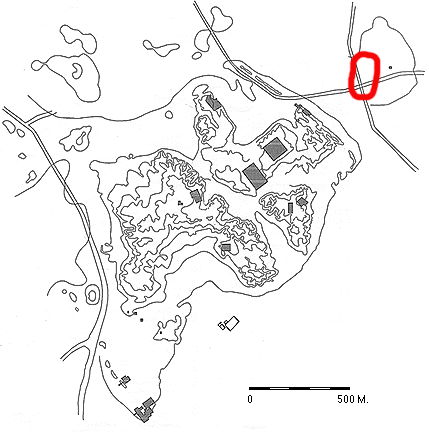
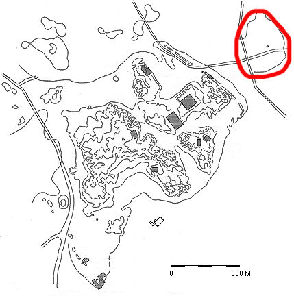
As a student in 1964, I examined all parts of Nippur (Fig. 1) with the intention of making a controlled collection of surface finds. But it soon became obvious that it was impossible at that time to make a statistically valid collection of the site as a whole. Dunes of sand and aparna covered more than three quarters of the site. Although the dunes would shift and leave a part of the surface exposed for a time, only a rough estimate could be made of surface remains. The more than four hundred dumps created by the Pennsylvania expedition in the 1890's and by modern excavators since 1948 created a special problem. Located on the eastern mounds and on the northeastern half of the West Mound, these dumps are useful in allowing one to view sherds and artifacts from deep levels that would not otherwise be represented so fully in surface material. But the presence of this early material on dumps skews any overall surface collection strategy. The southwestern half of the West Mound, where there was almost no Pennsylvania activity, does not display the same quantity of earlier artifacts on the surface as does the rest of the site.
When I became director of Nippur in 1972, I initiated an environmental archaeological program intended to examine the city of Nippur through time in relation to the changing ecological system. This program has had a number of emphases, including the solving of stratigraphic problems and the setting up of a new artifactual sequence; the integration of information from environmental, inscriptional, and artifactual sources; the correlation of objects with one another and their findspots; the investigation of differences and similarities between sacred and secular buildings as shown by the artifacts in them; the determination of specific locations for industrial or commercial activities; and the outlining of a settlement history for the city, with indications of growth and decline. We set out to accomplish the aims of the program through excavations, surface collections, and environmental investigations (faunal, floral, geomorphological).
In 1973, and again in 1975, the Nippur expedition made surface collections at specific locations on the mounds, using the 42 permanent concrete surveying markers as the centers for 10-meter-radius collection circles. The sherds were recorded by type, drawn, and given provisional dates. In these two operations, we were able to make a more thorough collection of the West Mound than in previous years due to the fact that the dunes had begun to move toward the southeast, leaving parts of the high mounds and the entire southern end and western edge of the site exposed. At present, there are very few dunes on the high mounds and these will be gone in a few years.
The low apron of tell that extends from the edge of the high West Mound to the southern corner of the site (our Area WC) is relatively flat and had never been excavated before we put in test trenches at WC-1 and WC-2 in 1973. The low area is, therefore, an excellent location in which to employ surface collection techniques. The controlled collection in 1973 showed that there was no occupation on this low apron later than the mid-first millennium B.C. There was occupation there possibly as early as the Akkadian period, along with abundant evidence of Ur III, Kassite, and early first millennium settlement. Because there were no later building levels, we could expose considerable portions of these early occupations with much less effort and cost than would be required on the high mounds. An added attraction of the area was the fact that in 1973 the dunes had already moved from this area. We decided to shift all our excavation efforts from the high mounds to Area WC in 1975 (Fig. 1). Excavations in that and subsequent years proved that the surface sherds had given a very good representation of the levels and the lateral extent of settlement to be encountered in Area WC.
On the high mounds, however, when we compared the results of our collections with the evidence from excavations carried out at Nippur since Pennsylvania opened its operations in 1889, it was apparent that surface indications could not be relied on for information on the date and extent of settlement in most periods. The main cause of the problem is not the long history of occupation at the site, but the building activities of the Parthians, who constructed huge buildings across most of the high mounds in the first and second centuries A.D.
The construction methods of the Parthians involved the excavation of very large and deep trenches (as much as 100 m. long x 30 m. wide x 5 m. deep). In each huge trench, the Parthians laid foundation bricks along the perimeter of the building, a few courses at a time. As the brickwork of the foundations rose, the large space within was filled with debris that had been removed from the trench or from other places on the mound. The fill of the foundations therefore consisted of dirt and artifacts from heterogenous sources and from numerous earlier periods. This building method created difficulties not only in relocating ancient material within Parthian constructions, but also in depositing Parthian artifacts next to very early material. Thus, it is improbable that one could take the information from a few, small, isolated soundings and establish the actual ancient contours of the site, as McCown and Haines tried to do.[1] Such soundings can be helpful as an adjunct to more extensive excavations, however.
Especially important as a factor in making surface collections unreliable was the fact that the Parthians derived their raw material for mudbrick from the unoccupied parts of the ancient site. I would propose that the Parthians wanted to have sherds in their bricks to act as binders. Bricks of this time were of such a large size that straw, the usual binder, was not sufficiently strong. With the sherds in them, Parthian bricks are so strong that even today they break into large pieces rather than shatter as strawtempered mudbricks do. As a result of the deliberate choice of sherd-rich debris as a raw material, early sherds can be seen in any exposed Parthian wall on the site. When we demolish Parthian walls, we routinely collect not only Ubaid sherds, but Ubaid lizard-headed figurines, Uruk-period cones of clay and stone, baked-clay sickles, Early Dynastic solid-footed goblet bases, items with cuneiform inscriptions, fragments of stone statues, and other artifacts datable to a variety of prehistoric and historic periods. On any part of the mounds where Parthian buildings once stood, early objects have been deposited on the surface as a result of erosion.
Judith A. Franke made a concerted effort in 1966-67 to localize the Ubaid settlement at Nippur and found sherds as early as the Hajji Muhammad phase scattered over all the high mounds, even on the unexcavated part of the West Mound. If one were not aware of Parthian construction practices and were to assume that the scatter on the surface reflected the subsurface occupation, great errors would result. The Hajji Muhammad sherd scatter, for instance, would indicate that Nippur had been a city of more than a hundred hectares by about 5000 B.C. Such a size is out of the question for that early a time.
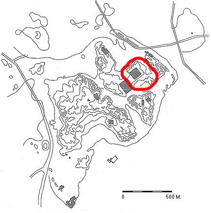
We are fairly certain that the large, low depression within the city wall immediately northwest of the ziggurat (Ekur, Fig. 1) was the location of the principal Parthian "quarry." [2] The identification of that area as the main source of Parthian mudbricks is most persuasively argued by the fact that Hajji Muhammad sherds have been encountered in excavation at Nippur only in soundings within the basin. The Hajji Muhammad levels, and even the Uruk strata, are deep at Nippur (more than 3 meters below the present plain) and this "basin" is the only large, obviously-excavated location that could have supplied the quantity of raw material necessary for the Parthian constructions.
In the series of site plans that follows, I attempt to give some idea of the size of occupation at different periods. There is a considerable measure of guessing for most of the earlier periods, since the surface collections can be relied on as real indicators only in the low-lying portions of the site, mostly on the southern and western fringes of the West Mound. For the later periods, from Parthian on, the plans are based substantially on surface collection. For all pre-Parthian periods, however, we have the information gained in the past forty years of modern excavation at the site, supplemented by the publications and the body of notes from Pennsylvania's expedition in the 1890's. The publication and notes of John P. Peters, John Henry Haynes, Joseph Meyer, and Clarence Fisher are especially useful. [3] I have found them to be reliable in details of findspot and relative stratification, even when mistaken as to the dating of specific layers or the interpretation of artifacts and buildings. But Hermann Hilprecht's archaeological notes and especially his major interpretative publication [4] must be used with great skepticism and caution; they can be relied on only when buttressed by corroborating evidence, especially Fisher's notes and publication.
Settlement information to be derived from excavations is best on the eastern mounds. Here, dozens of trenches by Pennsylvania, together with the major operations (Ekur, Inanna, TA, TB, North Temple) and 22 soundings of the Joint Expedition [5] allow a relatively full sampling of the material to be encountered in this half of the city. Our recent work on the eastern city wall (Areas EA, EB, EC) and at Tablet Hill (Area TC) have allowed us to assess and verify or correct the findings of earlier excavators. On the West Mound, the very extensive trenches by Pennsylvania in its southern end and at the site of the Court of Columns (our Area WA), plus our excavations in Areas WA and WB (1972-73), give us a fairly good idea of the levels to be encountered within a strip of about two hundred meters on the southwestern side of the deep trough that divides the city. This trough, called the Shatt an-Nil by local people, is probably the most ancient bed of the Euphrates. For the rest of the high ridge of the West Mound, we have only limited evidence of pre-Parthian stratified material visible occasionally in the eroded sides of gullies. Thus, in the following presentation, the occupation on the western end of the high West Mound is highly questionable and the hatching might be extended farther along the ridge in any pre-Parthian period.
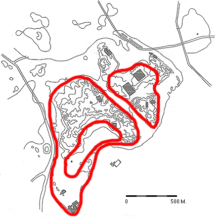
The plan of the city with the proposed extent of occupation in the Ubaid and Uruk periods (Fig. 2) is necessarily speculative. Only in soundings in the basin northwest of the ziggurat [6] has material of the Ubaid range been found in original context. The soundings make it possible to argue that some part of the eastern half of the site was occupied from the Hajji Muhammad phase of the Ubaid onward. One would also assume that the location under and around the Ekur was, even at that time, the site of the central shrine of the town. We cannot define the full extent of the Ubaid settlement, nor determine whether it lay on both sides of the river.
The situation in the Uruk/Jemdet Nasr periods is somewhat clearer. Uruk pottery, including beveled rim bowls, was found at the southwestern edge of the basin. [7] Material of Uruk and Jemdet Nasr date was discovered in the bottom of the Inanna Temple operation. [8] In Figure 2, I show the Uruk/Jemdet Nasr settlement extending to the West Mound because we have found a few sherds of this date in Akkadian through Old Babylonian contexts in Area WA. Until actual strata of this range are excavated on the West Mound, the pre-Early Dynastic occupation there must remain an assumption.
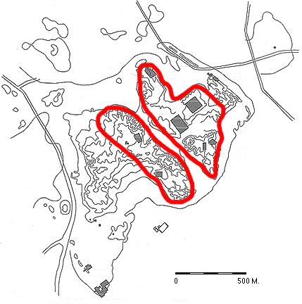
In the Early Dynastic and Akkadian Periods (Fig. 3), the city was probably much larger than previously. The Pennsylvania excavators noted that there was an Early Dynastic platform or terrace under the entire sacred precinct. [9] In our work at Area EA (Fig. 1) in 1987, we found confirming evidence that the sacred area around Ekur must have been two to three meters higher than the surrounding town in the Early Dynastic period. We can also say from our work in Area EA that the city wall exposed in the northeastern part of the city [10] can be dated from as early as Early Dynastic I. Along the northeastern face of this wall Pennsylvania found evidence of an Early Dynastic watercourse [11] which we think was a canal dug from the Euphrates before it passed through the city. Our continuing program of geomorphological investigations will, we hope, help to detail the history of water courses related to the site.
Early Dynastic sherds found in Akkadian levels in Area WA have led me to propose that the city was located on both sides of the river at least by this period, if not earlier. [12] We cannot say for certain how far the city extended to the west, not having located the Early Dynastic western city wall as yet. Judith A. Franke [13] argues convincingly that the wall ran approximately along the southwestern edge of the hatched area on Figure 3. In excavations at Area WB, she noted that the Isin-Larsa and Old Babylonian levels of buildings were much higher than those that have been found in other excavations at Nippur. She proposes that these buildings were higher because they are resting on the original western city wall. We hope to investigate the possibility of there being an early city wall under Area WB and west of Area WA in a forthcoming season of excavation.
A massive mudbrick and baked brick wall that Pennsylvania discovered and followed for over "600 feet" [14] at the southeastern tip of the West Mound might have been Early Dynastic and Akkadian and would have been the termination of the original western city wall, but it cannot be precisely dated. Part of it may have been an Ur III construction, however. The only baked-brick city wall construction we have encountered was a foundation under one portion of the city wall in Area WC-1 which must be dated to Ur III. The construction found by Pennsylvania at the tip of the West Mound was described as being in several phases, composed of a mudbrick platform faced with baked bricks. [15] An additional facing was thought to date to the period of the Parthian fortress. [16] This complex of construction would benefit from further excavation.
Tablet Hill, the more southerly of the eastern mounds, was possibly not occupied until the Early Dynastic or Akkadian Period. Excavations were halted in the Akkadian level [17] before virgin soil was reached in this mound. It is, however, probable that not a great depth of deposit remained unexcavated. Judith Franke [18] has pointed out that the Akkadian level in TB rested at about 80 meters above datum. This was about the same depth as much older (Early Dynastic I) strata found in Haines' sounding K-1. [19] She argues that Tablet Hill was, therefore, essentially unoccupied before Early Dynastic times. We intend to sink a stratigraphic pit in the bottom of Trench TB to investigate this question in the very near future.
In our work in Area WC, at the southern corner of the city, we found no occupation earlier than Ur III. Sherds that we had thought fifteen years ago were diagnostic for the Akkadian period (such as jars with multiple ridges on the shoulders) have proven to be equally diagnostic for early Ur III as for the later part of the Akkadian period. In excavation of Area WC-3, we have been able to establish the entire range of Ur III pottery within well-sealed strata that rest immediately upon virgin soil.
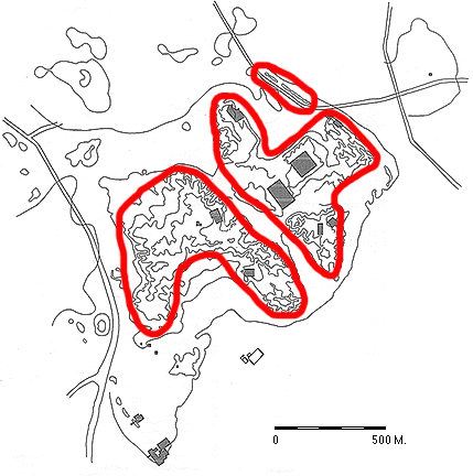
During the Ur III Period (Fig. 4), Nippur reached its greatest size, approximately 135 hectares according to an estimate by R. L. Zettler. [20] In addition to numerous exposures of Ur III structures on the high mounds, houses and an administrative building have been found in the southern part of the site. The buildings in Area WC date from at least the reign of Shulgi, if not of Ur-Nammu, but no defensive wall was built here until late, probably in the reign of Ibbi-Sin. [21] On the northwestern perimeter of the site an island may have been constructed to block access along the Euphrates. The structures on this island were excavated by Pennsylvania, but I have not yet been able to locate the notes on this operation.
In Isin-Larsa/Old Babylonian times, the city shrank in size (Fig. 5). The entire southern end of the mound was abandoned. But we know from excavation that the eastern half of the city flourished, as did at least parts of the West Mound. We cannot say whether the area of the basin north of the ziggurat was occupied during these periods. I have the impression that the entire city wall, including the part in this area, was no longer functioning as a structure but was only a ridge.
Within the reign of Samsuiluna (1749-1712 B.C.), the city of Nippur was totally or virtually abandoned, presumably because of problems with the water supply. Because dated tablets ceased to be written at Nippur in the reign of Samsuiluna and as far as we know dated documents did not reappear at the site until the Kassite period, [22] we knew that there must have been some kind of major change in the city. We first found evidence of an environmental shift and a possible abandonment while working in Area WB. Here Judith A. Franke, [23] using tablets and a newly-constructed ceramic sequence, was able to assign a date of approximately 1736 B.C. to an abandonment of houses, followed by an accumulation of sand and aparna. Subsequent to the work in Area WB, we found evidence of the abandonment in Areas WA and TC. Elizabeth Stone, [24] in her restudy of Tablet Hill, presents an argument for agricultural crisis at Nippur and suggests the cause may have been a problem with the supply of water. She would date the full abandonment at Nippur to about 1720 B.C.
I rather doubt that even a small village could have survived at Nippur without water, but I have allowed for the possibility (Fig. 6), assuming that wells dug in the middle of the old river bed could have supplied enough water for a skeleton staff at Ekur after Samsuiluna's time. We have definite, excavated evidence in Area TC of the presence of aparna dunes on the site after the abandonment and propose that the landscape at that time was much as it has been in the Nippur region for the past forty years.
One reason for supposing some occupation after Samsuiluna is the fact that when the site was reoccupied in the Kassite period, presumably in the reign of Kurigalzu I (early fourteenth century s.c.), [25] there was enough knowledge of the location of temples to allow the building of new versions on the ruins of the old. For instance, the Kassite Inanna Temple was built above the ruins of the Ur III building. But the Kassites might have been able to determine the nature of ruined buildings just from the plan of the structures, even after centuries of abandonment. A bit of digging at doorways for pivot stones or foundation deposits would have allowed the identification of the structure. I have some problem in accounting for the survival of unbaked mudbrick architecture over a three hundred year period, given the deterioration caused by salt. We have photographs recording the decay of the Pennsylvania dig house at Nippur to its present condition, a mound, in only eighty-nine years. But in areas that have been deprived of water, salt action is much reduced and decay of mudbricks is greatly retarded. I have walked through Ghaznavid buildings (circa twelfth century A.D.) in the southern desert of Afghanistan, where mudbrick walls still stand three to five meters high and the plan of the structure is easily recognizable.
Tablet evidence and excavated remains indicate that the recovery of Nippur as a major city took place in the fourteenth and thirteenth centuries s.c. [26] Kassite levels have been excavated in several locations on the east mounds and in Areas WA, WB, and WC to the west (Fig. 7). Of great importance was the finding of an administrative building, probably of the Kassite governor, in Area WB. [27] Surface collections on the low areas at the southern and western fringes of the site confirmed a spread of Kassite occupation to the city's limits, accompanied by a new city wall. [28] As indicated on the ancient map of Nippur, the Euphrates ran to the west of the city at this time; during the fourteenth season, we cut a trench across a well-preserved canal west of WC and found that it could be dated by pottery to the Kassite period. The trough dividing the eastern and western mounds, which I have proposed was the original bed of the Euphrates, was now merely the "Canal in the Middle of the City." [29] In front of the new city wall that we excavated at the southern end of the city, there is evidence of a ten-meter-wide moat, which cut away the face of the Ur III city wall. [30] Our excavated findings seem to match the ancient map in a number of details.
Two pits (Area WD) at the bottom of the slope of the high West Mound yielded no occupation layers from the surface to below plain level, but only sand, clay and sherds that had been washed from the high mound. I have indicated this area of non-occupation by omitting the hatching here (Fig. 7). I would account for this lack of occupation by reference to the Kassite city plan, which mentions gardens in the southern end of the site. The large Kassite houses found just inside the city wall at WC-1 and WC-3 would, then, have been elite houses built within the gardens.
Archaeologically, the span of time from the Kassite dynasty until the eighth century is evidenced in some work in the ziggurat precinct, a few centimeters of debris in Area TC, and some crude shelters built inside the ruins of the Kassite palace at Area WB. [31] In other excavated areas, there is either an erosion surface as in the North Temple [32] or some other kind of break in stratigraphy (as in Area WA 50c). [33] Erosion may have obliterated some signs of occupation in the post-Kassite era, but the evidence indicates that for a good part of the time the site once again may have been reduced to a village around the ziggurat (Fig. 8).
According to cuneiform records, there was at Nippur building activity by the kings of the second Isin Dynasty. [34] Continued occupation was also documented [35] for the reign of Adad-apla-iddina (1068-1047 B.C.), when the city was sacked and the statue of Enlil was carried off by Sutians and Arameans. Adad-apla-iddina claimed to have repaired Nemed-Marduk, the outer wall of Nippur, [36] but we have not found archaeological evidence as yet of this work on the spur of wall running north of the ziggurat or on the city wall at the southern end of the city, Area WC.
Although we have found no buildings between the Kassite period and the seventh century, a duck weight with an inscription mentioning Marduk-shapik-zeri [37] was discovered just outside the eastern face of the present-day expedition house. When the site was being graded for the erection of the expedition house in 1964, it was possible to see some signs of niched and buttressed architecture below the surface. Clearly, there is a major public building under part of the expedition house, but it is probable that the structure dates to some time later than the manufacture of the duck weight. An exploratory trench planned for a coming season may date the building more exactly. I have put hatching in this area on Figure 8 on the basis of the weight, but I do not think it is likely that the area was occupied between the Kassite period and the seventh century.
The first king of the second Sealands Dynasty, Simbar-shipak (1026-1009 B.C.), repaired the throne of the god Enlil in Ekurgigal. [38] After that no records are known from Nippur until the eighth century.
The city revived and had a governor of considerable importance in the eighth century, [39] according to tablets found around a burial in Area WB. [40] The city once more reached a remarkable size in the seventh century (Fig. 9), under Shamash-shuma-ukin and Ashurbanipal; major construction included a restoration of the ziggurat and a new city wall of mudbricks at the southern end of the site. The city wall of the seventh century was less than five meters wide, but was accompanied by a double-stepped outer defensive wall with a fosse, set into the filled-in Kassite moat. [41] We do not yet know where Nippur's main water course ran at the time. The Kassite canal to the west of Area WC was no longer in use. Probably the main course ran through the city once again.
As in the Kassite period, the area between the WC houses and the West Mound (Area WD) seems not to have been used for buildings in the seventh century. It should be mentioned that just north of the excavations in Area WC-2, we can see in aerial (kite) photographs the plan of several large buildings, including one that appears to be a substantial palace, presumably datable to the seventh century. We expect to investigate these buildings in the near future.
During the Neo-Babylonian period (Fig. 10), the WC area may have continued to be occupied for a time, but the general impression is of a decline and eventual shrinking of settlement to the high mounds. Even on the high mounds, however, the occupation may not have been uniform. In the North Temple area only a few floors and bits of wall were found, [42] while in other areas of the West Mound substantial buildings were occupied. In Area WA a very impressive temple was constructed during this time.
The Achaemenid period saw a continuation and perhaps an expansion of the city. Finds in Achaemenid levels in Areas TA and WA are generally rich and include coins from Greek states in Anatolia and mainland Greece as well as numerous items from Egypt. In the North Temple area at this time there was "considerable building activity." [43] A hundred meters or less to the west of Area WA, where we exposed an Achaemenid period temple, [44] Pennsylvania discovered the Murashu archive. I expect the western end of the high West Mound to show substantial Achaemenid construction when it is excavated.
The Seleucid and Parthian eras (Fig. 11) witnessed major occupation at Nippur. Seleucid houses have been partially excavated on Tablet Hill, above the North Temple, and in Areas WA and WB on the West Mound. If we can judge by the considerable number of Seleucid coins found in surface collections on all of the high mounds, we can say that the site was very important at this time. Off the main mounds, but touching the eastern corner of the site, is a low tell (not on plan) that yielded pottery and about a dozen coins of Seleucid date in surface collections. This site blends into a large Parthian-Sasanian mound called Ishan al-Sahra, farther southeast (not on plan).
The Parthian occupation at the site was extensive, probably making Nippur one of the largest cities of the period in southern Mesopotamia, although it was not developed until after the time of Christ and mostly after 100 A.D. The Parthian fortress around the ziggurat, the Parthian level of the Inanna Temple, and the Court of Columns excavated by Pennsylvania (=our Area WA) are among the most impressive ruins of any period at the site. Some large mudbricks visible at the top of the Ur III city wall that runs northwest of the ziggurat seem to be Parthian. Until we can reinvestigate the construction, I will assume that these bricks were part of a Parthian defensive wall.
The city continued to thrive through the Sasanian and Early Islamic Periods (242-750 A.D.) and into the Early Abbasid (Fig. 12). During this stretch of time Nippur experienced one of its peaks of occupation. The major part of the settlement seems to have been on the West Mound. A string of small tells along the western edge of the city may mark the bed of the most important canal of the time. The old bed of the Euphrates, through the middle of the site, was presumably still used as a canal, however. An area of Early Islamic pottery production, with several deteriorated kilns, wasters, and mounds of ash, lies between the ziggurat and the northeastern city wall. There is no evidence of contemporary houses in this location. The mound called Ishan al-Sahra, southeast of Nippur, was predominantly a Sasanian settlement.
After having remained a vigorous city until about 800 A.D., the main mounds were abandoned and subsequent Abbasid settlement in the area was confined to a small village alongside a very large, easily visible, new canal northeast of the ziggurat (Fig. 13).
In the Ilkhanid period (Fig. 14) a new canal was brought from the northwest down inside the basin north of Ekur, along the ancient city wall, then was cut through the wall and the disused Abbasid canal to water a low site five hundred meters to the east before it continued southwards. This site, Area M, was collected and excavated by us in 1985 and 1987. Datable to the Ilkhanid/Timurid period (fourteenth and early fifteenth centuries A.D.), this town was the last occupation in the Nippur vicinity before the hamlets and villages of the Ottoman period, some of which are still being occupied.
I have presented here a sketch of Nippur's settlement history that is subject to change with further excavation. Despite its necessarily speculative features, I hope it may prove useful to scholars in assessing Nippur's place in its historical and geographic setting.
