
John C. Sanders, Head
Oriental Institute Computer Laboratory
Peggy M. Sanders
Archaeological Graphic Services
The Oriental Institute established a Computer Laboratory in July, 1990, to facilitate and encourage the use of computer technology by the faculty and staff in their analysis of the ancient Near East. The Laboratory provides faculty and staff with technical assistance in the selection, development, and operation of specific computer applications, including word processing, database management, and graphics. Additionally, the Laboratory contains some technologically advanced equipment. This equipment allows the computer laboratory staff to work closely with Oriental Institute archaeological expeditions to produce sophisticated computer models and graphic images of their sites.
Giza Plateau Computer Model
In the spring of 1991 public television station WGBH, in Boston, contacted Professor Mark Lehner, the Oriental Institute's Egyptian archaeologist, with the idea for a show to be broadcast in their NOVA series, investigating the construction of the Giza pyramid complex. One part of the show was to be an animated "fly-over" of the Giza Plateau as it might have looked at the time the pyramids were being constructed.
Space Shuttle Photograph Of Giza Area
To accomplish this a computer model of the entire plateau and its architectural components had to be created from published maps, survey, and excavation reports. Peggy Sanders, an independant computer graphics specialist with Archaeological Graphics Services, was contracted to build the three-dimensional graphics database of the Giza Plateau and its architecture. Prof. Lehner supplied the Computer Laboratory with a one-meter contour map showing the topography of the Giza Plateau. The original Giza area map was broken down into 25 500 x 500 meter squares. The contour lines in each square were "digitized" into drawing files using the AutoCAD graphics program on an IBM personal computer. Once all 25 squares were completed these files were processed with an AutoLisp program to extract the X,Y,Z coordinates for every line segment of each contour, producing an ASCII data file of just over 100,000 point proveniences for a 3.5 by 4 kilometer area of the Giza Plateau. This file of point proveniences was then used to generate a three-dimensional surface terrain model of the Giza Plateau using the ARRIS graphics program, from Sigma Design, Inc., and an add-on module called Topographer, from Aritek Systems, Inc., on a Sun SPARCstation 1+ computer. This initial phase of the project took approximately six months to complete.
I would like to thank Mr. Al Hart and Mr. Dan Moore, of Aritek Systems, for their assistance in this project. The need to process over 100,000 data points to generate a single surface model required modifications to the Topographer program itself, changes which they graciously undertook at no charge and which have now been incorporated into the latest release of the Topographer program. We could not have produced the Giza Plateau model for the NOVA production without their help, and that of the entire Aritek Systems staff.
After completing this preliminary Giza Plateau surface terrain model, the Computer Laboratory constructed basic three-dimensional volume models of the architectural monuments on the Giza Plateau. Various publications of the architectural complexes on the Giza Plateau, obtained from the Oriental Institute's Research Archives, were used during this phase of the project. The often differing scaled plans and sections obtained from these publications were discussed and evaluated, and overall dimensional information for each pyramid complex was arrived at in consultation with Prof. Lehner. These building components (the ten Giza pyramids, mortuary and valley temples, causeways, the Sphinx Temple, and circa 150 mastaba tombs) were then built in three-dimensional wireframe geometry using AutoCAD on the IBM computer, and shipped to the ARRIS graphics program on the Sun SPARCstation 1+ computer using AutoCAD's DXF file format. Using the ARRIS program's Modeling and Rendering module, each wireframe model had surface geometry applied to it so that it could be rendered as a solid object, and then each was added to the surface terrain model in their appropriate locations. This second phase of the project took approximately two months.
The underlying data for the Giza Plateau model are not available to the public at this time. When the basic model is finished we will determine how and to whom the model will be made available.
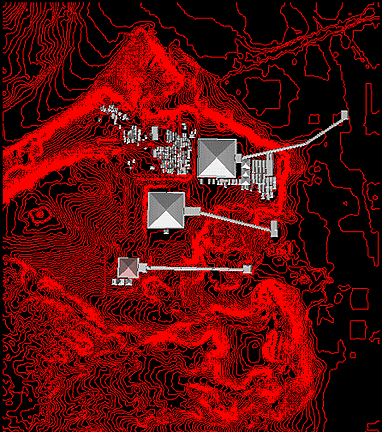
- Wireframe Topography and Rendered Structures in Plan View
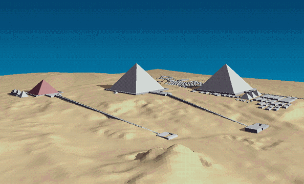
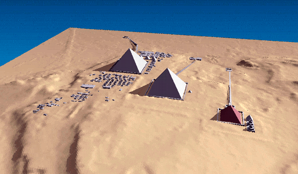
- Rendered Plateau Model from South
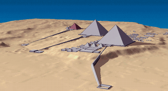
- Rendered Plateau Model from Southeast
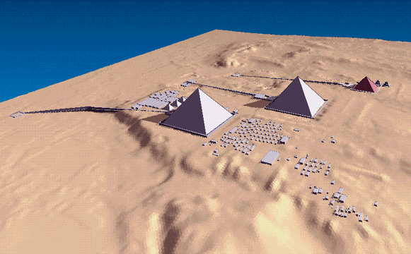
- Rendered Plateau Model from Northeast
- Rendered Plateau Model from Northwest
- Rendered Plateau Model from West
- Rendered Plateau Model from Southwest
With the preliminary computer model of the Giza Plateau and its pyramid complexes completed, animation software could process this database to permit one to "fly" into, around, and through the model, and record what one sees on videotape. Because the Computer Laboratory did not have the animation software necessary to accomplish this, a copy of the Giza Plateau computer model was shipped to an architectural firm in Venice, California, The Jerde Partnership. They had assisted Prof. Lehner with his computer mapping of the Sphinx during the 1980's, and were willing to contribute to this project as well. With Prof. Lehner's assistance, Tom Jaegers, the firm's computer specialist, merged their AutoCAD surface model of the Sphinx with a DXF translated version of our Giza Plateau surface model, decided on the path of the "fly-over", added a sky backdrop, and produced the 45 second video sequence that was seen in the NOVA special entitled "This Old Pyramid", which was broadcast on November 4, 1992.
Beyond this "popular" use for the Giza Plateau database, future enhancements to the basic computer model are already underway which will greatly increase its use and potential for analytical and educational studies. One by one, each of the architectural volume models will be replaced with more accurate and detailed three-dimensional reconstructions of the architectural constructions on the plateau. Peggy Sanders has spent many long hours during the past year painstakingly constructing very detailed three-dimensional geometry for several of the temple complexes from the same published sources mentioned above. Detailed architectural models have now been completed for the following monuments: Khufu Pyramid Complex; Khafre Pyramid Complex; Menkaure Pyramid Complex; and the Sphinx Temple.
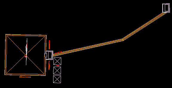
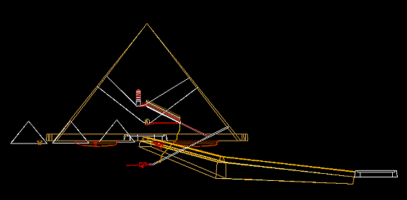
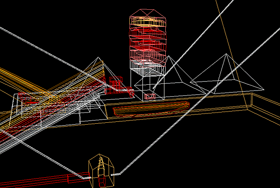
- Khufu Pyramid Complex, Wireframe Model In Plan View
- Khufu Pyramid Complex, Wireframe Model In Elevation
- Khufu Pyramid Complex, Wireframe Model In Isometric View
- Khufu Pyramid Complex, Wireframe Model Detail
- Sphinx Temple, Wireframe Model In Isometric View
- Sphinx Temple, Rendered Model In Isometric View
The final step in the process of creating these three-dimensional building models will involve the "texture mapping" of appropriate building material finishes, and the superimposition of scanned images for any wall reliefs and inscriptions onto the surfaces of the Giza monuments. When this process is completed, this more detailed model of the Giza Plateau and its architectural complexes will also be able to be processed by the same type of computer visualization and animation software used in the NOVA production. The analytical and educational potential of this database, however, will far exceed the popular use of its predecessor.
Additional work in "re-contouring" the plateau's surface is also planned, in order to produce four separate computer models of the Giza Plateau in accordance with Prof. Lehner's reconstructions of the different stages of the plateau's development: before any construction was undertaken, and after each of the Pyramids of Khufu, Khafre, and Menkaure were built.
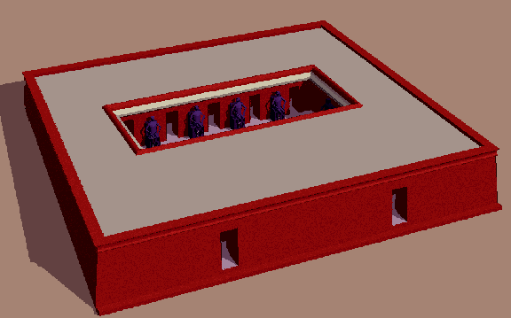
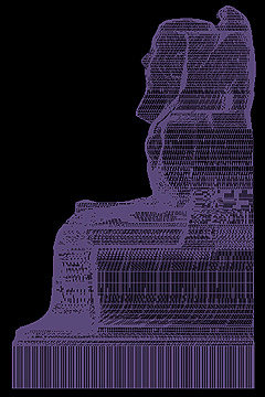
With the Sphinx itself having been modeled by the Jerde Partnership in the 1980's, one other architectural component of the Giza Plateau presented peculiar difficulties for three-dimensional modeling. To fully recreate the architectural features of the Sphinx Temple, the Laboratory was faced with constructing computer models of the ten, larger than life-size, statues of the seated pharaoh Khafre, which were located around the periphery of the courtyard of the Sphinx Temple. Because the Oriental Institute's Museum collection does not contain any artifacts which duplicate the position, clothing, and crown of the required statues, as envisioned by Prof. Lehner, Peggy Sanders sculpted a scale model of the figure in clay (Clay Model of Sphinx Temple Statue). The foot high statue was then taken to the Biomedical Visualization Laboratory at the University of Illinois at Chicago, where, with the help of Director Louis Sadler and his staff, a laser scan was made of this statue, resulting in an ASCII data file of some 70,000 discrete three-dimensional data points which precisely model its surface geometry.
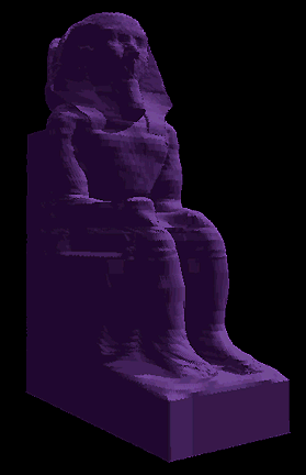
During the fall of 1993 this data file was processed using the AutoCAD program into a drawing file containing a series of contour lines through the statue from top to bottom (Wireframe Model of Sphinx Temple Statue, In Elevation). Ruled surface geometry was than applied between each pair of adjacent contours, resulting in a surface model of the seated pharaoh Khafre. Once again, a DXF version of the statue database was transferred to the Computer Laboratory's ARRIS graphics program to render (or "solidify") the statue.
- Rendered Model of Sphinx Temple Statue, In Isometric View
- Rendered Detail of Sphinx Temple Statue, In Isometric View
Two of these statue models were appropriately scaled, and ten copies were then inserted into the overall Sphinx Temple model (Rendered Sphinx Temple Courtyard with Statues). Although a complex process, it resulted in a very detailed and realistic recreation of not only the ten statues but the entire courtyard area within the Sphinx Temple.
Saqqara Computer Model
Besides these monuments from the Giza Plateau, Prof. Lehner also asked the Computer Laboratory to create similar three-dimensional models for the architectural complex at Saqqara, south of Giza, to be included in the publication of a new survey of the Egyptian pyramids by National Geographic magazine. Peggy Sanders, of Archaeological Graphic Services, was contracted once again to construct the three-dimensional computer graphics database. To date, published plans and sections remain limited, and offer little assistance in visualizing the labyrinth of chambers and passages under the famous step pyramid. As was the case with the Giza Plateau project, these early publications did, however, supply the necessary information to create a new three-dimensional computer model of the Zoser pyramid complex.
- Wireframe Model of Saqqara Complex
- Wireframe Detail of Zoser Pyramid
While the initial motivation for this project was a future publication on pyramids by Prof. Lehner, another application for this model presented itself quite unexpectedly. Florence Friedman, Curator of Ancient Art at the Museum of Art, Rhode Island School of Design, asked Prof. Lehner if he knew of "better" plans of the subterranean chambers than were commonly available. Fortunately for her, our computer model of the Zoser complex was easily adapted to illustrate her forthcoming article correlating the three stelae beneath the step pyramid and the three stelae associated with the south tomb.
Conclusion
Both of these computer graphics databases will continue to be developed over time. Additional architectural elements and details will be added to each, and their use as an analytical tool of archaeological investigation and publication is just beginning to be explored.
SEE ALSO: RECENT WORK ON THE GIZA PLATEAU COMPUTER MODEL (1997-1998)
Questions concerning the development of the Giza Plateau computer model should be addressed to:
- John C. Sanders, Head
- Oriental Institute Computer Laboratory
- University of Chicago
- 1155 East 58th Street, Chicago, IL 60637 USA
- (773) 702-0989
- (773) 702-9853 fax
- jc-sanders@uchicago.edu
- To Contact John Sanders Directly
