
Preliminary Report, 1999
K. Aslihan Yener, Christopher Edens, Jesse Casana, Benjamin Diebold, Heidi Ekstrom, Michelle Loyet, and Rana Ozbal
The following article has been reproduced with permission from Anatolica No.XXVI (2000)
Contents
- Investigations at Tell Kurdu
- Microartifact Analysis
- Pyrotechnic Installations
- Ceramics
- Administrative Artifacts
- Domestic Equipment
- Chipped Stone
- Faunal Remains
- Archaeobotany
- Discussion
INVESTIGATIONS AT TELL KURDU
Chris Edens (University of Pennsylvania) and Aslihan Yener (University of Chicago)
Tell Kurdu is a large low bilobate mound covering about 15 ha sets on the deltaic fan of the Afrin, about 3 km east of the historic Lake of Antioch (see Fig. 1 for location); before the lake was drained, marshes extended along the northern edge of the site. The site encompasses two distinct mounds, a saddle running between the two. The higher south mound presents moderately steep slopes to the south and east, but elsewhere the mound presents very gentle topography. During the 1930s the smaller south mound rose nearly 9 m above plain level, while the larger mound in the north stood only 4 m high. Motivated by recent development of cash crops like cotton, local landowners have bulldozed and flattened areas around the edges of Tell Kurdu (readily evident in the current rectangular appearance of the south mound, see Fig. 2), and have pushed earth from the top of the south mound into the once deeper saddle to the northwest. Careful topographic examination of the site and its neighborhood indicates that the south mound has lost at least 1.7 m and probably closer to 2.3 m from its top.
During Amuq C times Tell Kurdu was the major settlement of the plain, and remained one of the main settlements into the Amuq E period. Settlement survey has recorded 30 sites that definitely or probably fall in the Amuq A-E range. While most of these settlements are small, on the order of 1 ha, several places in the center of the plain are considerably larger. Judging by intra-site surface distribution of diagnostics and Braidwood's excavation results, the settlement at Tell Kurdu covered around 15 ha during the later 6th millennium (Amuq C) when it was by far the largest settlement of the plain. By the early 5th millennium (Amuq E), Tell Kurdu had contracted to perhaps 5-7 ha on the south mound (but see the reassessment below); Tell `Imar, 3 km to the south, was also occupied at this time and may have been a substantial settlement. The two-tiered primate pattern suggests a degree of hierarchy and complexity during Amuq C-E times.
Braidwood placed four trenches in Tell Kurdu, three on the south mound and one on the north, during a hurried two week campaign in 1938. Digging in arbitrary levels, he carried Trench I, a 4 x 20 m exposure on the south mound, down 11.5 m to water table (not virgin soil) nearly three meters below plain level. The pottery from this trench forms the backbone of the Amuq C-E sequence, with the upper five meters of the trench representing Amuq E, the next 4.5 m Amuq D, and the lowest two meters Amuq C. The other two trenches on the south mound remained within Amuq E levels. On the north mound, Trench IV reached Amuq C levels within half a meter of the surface. Braidwood suggested that proximity of Amuq C material to the surface of the north mound, and the thick deposits of Amuq D-E on the south mound, implies earlier mounding in the north and later formation of the south mound. The same observations also suggest that the Amuq C occupation spread across the entire site area while the Amuq E settlement lay only on the south mound. AVRP chose Tell Kurdu as the first step of a long-term program of excavations at several different mounds. The larger program seeks to examine intra-regional and interregional dynamics through time in the Amuq plain. Tell Kurdu represents the Amuq C-E (and possibly earlier) portion of the regional sequence, a time during which settlement and probably a degree of social hierarchy emerged. The changing pottery styles point to interactions with the Halaf and `Ubaid worlds of northern Mesopotamia. As a regional center, Kurdu would have played a pivotal role in interregional interactions. These interactions are likely to have involved, among other factors, flows of raw materials from the neighboring Amanus Mountains (e.g. serpentine, other stones, timber, and potentially copper and other metals), and potentially craft production both for intra-regional consumption and for extra-regional export. The Kurdu excavations seek to investigate this set of issues in a community at the threshold of social complexity. The excavations also have the secondary but still vital goal of firming up and expanding Braidwood's Amuq ceramic sequence, both as tool for analyzing surface collections for the regional survey and as a contribution to the chronological framework of southeastern Anatolia and western Syria.
The work began in 1996 with a sounding in the south mound, placed on its eastern slope at the edge of the recent bulldozer cut (Fig. 2). The sounding revealed a mass of pisé architectural collapse and a dense mass of burnt grain, above a level of more intact but incompletely exposed architecture. The associated pottery was Amuq E in character, and two radiocarbon dates place the upper phase around 4800 cal BC (see Yener et al. in press for details). In 1998 excavation opened larger areas on both south and north mounds (Fig. 2). A 225 sq m exposure on the summit of the south mound (Tr 1/6/9) documented a wide platform and large architectural complex with grill rooms, open spaces, and ovens belonging to an early phase of Amuq E. A 100 sq m exposure on the east slope adjacent to the 1996 sounding (Tr 2) uncovered two blocks of small rooms and associated open space lying above a round building, all dated to Amuq E. A 100 sq m exposure on the east side of the north mound (Tr 4) found three Amuq E burials placed into a sequence of trash deposits, burnt architectural debris and concentrations of burnt grain, and more intact architecture of Amuq D date. In the central section of the north mound a 25 sq m trench (Tr 7) exposed Amuq C residential architecture and associated features. Elsewhere on the north mound exploratory trenches (Tr 5 and 10) documented additional architecture of undetermined date. A pilot magnetometry survey yielded mixed results, detecting substantial, possibly tripartite architecture on the north mound but yielding only ambiguous results elsewhere. The 1998 results corroborated Braidwood's observations about site formation, and also confirmed that different periods are readily accessible on different parts of the mound.
The 1999 season of the Tell Kurdu excavations had four basic objectives: (1) to further investigate an area of Amuq E architecture on the eastern slope of the south mound; (2) to begin a step trench down the east face of the south mound in order to create a more detailed ceramic chronology for the Amuq C-E periods; (3) to investigate architecture detected on the south mound during the 1998 magnetometry survey; and (4) to investigate the extent of disturbance and depth below modern surface of intact deposits on the northwest slope of the south mound. The second season of full-scale excavations at Tell Kurdu opened three major areas, and another three smaller portions of the site (Fig. 2). Each trench was excavated by a trench supervisor and assistant, and a team of 4-6 workmen from neighboring villages. Excavators used pick and shovel in poor contexts, and trowel and small pick in good contexts; sediments from secure contexts (e.g. floor, trash, pit deposits, burials) were screened (5 mm mesh) as samples that varied (0-100% of a given deposit) according to the trench supervisor's assessment of the context. This work revealed architecture, industrial areas, and associated trash deposits that belong to the Amuq E (or Ubaid-related, c. 5000/4900-4400/4300 BC) , Amuq D (c. 5200-5000/4900 BC), and a late phase of Amuq C (or Halaf-related, c. 5500-5200 BC) periods. In addition, a team from Bogazici University Kandilli Observatory conducted a magnetometry survey over two large portions of the site. The results of this work are presented in reverse chronological order.
Amuq E
Tr 11 and 15 were two 10 x 10 m squares placed along the west side of Tr 2, with Tr 15 encompassing the 1996 sounding (see Fig. 2 for locations). After the plowzone had been stripped off both trenches and the location of the 1996 sounding firmly identified, time allowed excavation only of the northern half of Tr 15 (north of the 1996 sounding). These trenches were intended to investigate further the complex of small roomed buildings and exterior spaces of Tr 2, to determine the wider context of the burnt architectural collapse and grain deposits of the 1996 sounding, and to identify firm stratigraphic links between the two earlier operations.
As elsewhere on the eastern slope of the south mound, the modern plowzone covered a deeply developed soil 50 cm thick, characterized by carbonate nodules and heavy bioturbation (in certain sections, identifiable animal holes make up roughly half the exposure). The deep bioturbation obscured stratigraphic context, leaving `floating' features of more durable materials (e.g. clusters of grinding stones in Tr 11). Although most of the artifacts in this soil were prehistoric, more recent objects like an early Byzantine copper coin also appeared.
The uppermost intact and coherent deposits in both trenches (phase 1) were the kilns, surfaces, other features and associated deposits of an industrial complex. This complex was most clearly preserved in Tr 11, where a set of four (perhaps five) kilns were set around two sides of a partially walled open space (Fig. 3). The kilns varied in shape (kiln 11:4 was square, kilns 11:6 and 11:7 were round, and kiln 11:8 was sub-rectilinear), but had similar dimensions and floor area (0.9-1.1 x 1.1-1.2 m, with floor areas 1.10-1.32 m2; see J. Casana below for further discussion). Shallow rectangular pits 11:16 and 11:19 accompanied the kilns in the same alignment; only 10-15 cm deep, these pits were filled with a fine silty soil. Poor preservation prevented identification of kiln openings, so the functional relationship between kilns and pits remains unclear. The perimeter wall 11:11, 11:17 and 11:18 formed the dog-legged northern edge of the complex, with kiln 11:8 and pit 11:16 set into the dog-leg. This wall, a 25-35 cm wide mud brick structure, was in places fire-hardened, especially in its western portions, but was lost to erosion to the east. The short stretch of walling 11:9 appeared in the southeast corner of the complex. Made of irregularly sized brick and baked hard and reddened, this structure may have been the fragment of an additional perimeter wall. The kilns and wall framed a surface 11:14, which consisted of a dense and very compacted laminated clayey silt that contained numerous flat-lying sherds and other artifacts; a notable proportion of the sherds were overfired wasters. Just as with the northern perimeter wall, erosion had truncated the floor to the east. Similarly laminated clayey silt surfaces appeared to the north (surface 11:13, fire hardened and reddened near wall 11:17/11:18), west (surface 11:20) and south (surface 11:15) of the complex. These accretion surfaces were 7-8 cm thick. In Trench 15 Phase 1 may have been represented by the extremely poorly preserved pyrotechnic facility 15:3. This was probably a kiln but it was so heavily damaged by erosion and plowing that this identification is not certain. A laminated clayey silt surface 15:5 comparable to those in Tr 11 extended eastward of the facility. Ephemeral traces of kiln flooring or other reddened and hardened surfaces appeared in western part of square.
Below the kiln complex, excavation exposed portions of four earlier buildings, together with associated surfaces and facilities (Fig. 4). Although most of these remains belong together as phase 2, certain stratigraphic uncertainties prevent grouping them all. First the buildings themselves will be described, and then the stratigraphic ambiguities will be discussed.
An erosional wash deposit of pebbly silt (loc 21) separated the phase 1 kiln complex in Tr 11 from a poorly preserved group of rectilinear walls and features (Building A). The wall 11:34, 30 cm wide and made of heavily chaff tempered pisé, formed the western margin of this unit. The rectangular installation 11:24, constructed of chaffy pisé and heavily burnt, sat on the north side of wall 11:34; this structure is very similar to the phase 1 kilns in form and intensity of burning. Floor fragment 11:23, also burnt, ran eastward from this installation; a broken pot lay upon this surface. An intentional fill of very dense clayey silt that contained occasional Amuq C sherds extended onto this floor, and served as the footing for the rectilinear burnt feature 11:35, which had a basin-like floor. South of wall 11:34, a pebbly and carbonate-rich clayey silt formed an exterior surface in which occurred flat-lying sherds. This surface enclosed the rectangular packed clay surface or floor 11:33, covering a 1.7 x 1.1 m area. Although no walls were associated with this surface, it is distinctive enough to be considered a floor, perhaps for an outbuilding constructed of reeds or similar material. In the southwest corner of Tr 11 walls 11:28 and 11:29, constructed of blocky gray-brown pisé, formed the corner of a room (Building D). Excavation inside the room (11:31) encountered grinding stones and an Amuq E bichrome jar but could not identify the surface upon which these material rested. Abutting wall 11:28 on the east was rectangular surface 11:30, paved with pisé slabs 10-15 cm wide laid in elongated rows sometimes with vertical sherds placed in the joints; a broken pottery vessel lay upon this surface. Ephemeral traces of walling seemed to frame this pavement, and the exterior surface 11:27 lay beyond to the north and east. Four small circular features in surface 11:27 framed the paved surface 11:27, and may represent post footings for an awning. The two features along the north side of the pavement were packed with sherds, bone, and other debris, while the two along the east side were filled with blocky clay similar to pisé wall material. Surface 11:27 extended northeastward, and framed the `U'-shaped oven 11:25 north of Building A. The pit 11:32 was later cut into pavement 11:30 and surface 11:26, and remains unphased.
In the western end of Tr 15 walls 15:12, 15:14, and 15:23 framed two rooms in the corner of Building C (Fig. 4). These walls varied somewhat in their construction: wall 15:14 was a 60 cm wide double coursing of fine gray pisé with pebble inclusions, walls 15:12 and 15:23 a single 30 cm wide course of fine gray chaff tempered pisé. The room fill 15:10 contained a broken pot and reed impression upon a fragmentary burnt floor, all buried under wall collapse. Outside the building, the deposit 15:18 (=15:13) ran over the stub of wall 15:12 in places and also both covered and enclosed the unexcavated feature 15:19, an oval ring of burnt clay surrounded by gray ashy soil (perhaps an oven). Further east were two additional ovens. Oven 15:7 was a domed oval, about 1 x 1.6 m in area, within a thick (30 cm) rectilinear encasing wall; the ashy contents included abundant burnt grain. Burnt collapse 15:9, mixed with ash and burnt grain, lay against this oven and covered the similar oven 15:21, exposed but not excavated in 1999. A third smaller (perhaps .5 x .8 m) rectilinear installation (feature 15:8) lay to the south; with only its southeast corner and floor preserved, the nature of this facility remains unclear. The fine silty deposit 15:20, which contained dense burnt grain, dipped sharply eastward from the collapse 15:9 toward Building C.
A room formed by walls 15:15 and 15:11 occupied the eastern end of Tr 15 (Building B). As with Building C, these walls were constructed in different manners. Wall 15:11 was built in a 75 cm wide double coursing of brownish gray blocky pisé, and wall 15:15 consisted of a 40 cm wide single course of finer gray pisé (with some blocky admixture and burnt grain inclusions). The wall closing off the western end of the room was difficult to discern, this area being heavily disturbed by animal burrows. The two walls ran into the eastern section and Tr 2. Although wall 15:11 appears to be an extension of wall 2:22 (Tr 2 phase 2), they actually seem not to be on the same alignment, thus creating a stratigraphic question resolvable by future removal of the baulk between the two trenches. The contents of the room 5:16 included a dense concentration of burnt grain, but excavation reached neither a floor nor seemingly the base of the walls. The silt deposit 15: 20 with burnt grain may either run against Building B or continue beneath this structure.
The stratigraphic relationships among these buildings remains unsettled. Buildings C and D were most likely in contemporary use, given their orientation and elevation. The group of ovens in Tr 15 fall into at least two different phases, with ovens 15:7 and 15:8 associated with collapse 15:9, which covered oven 15:21; oven 15:19 also seems older. The exterior deposit 15:18 forms a solid link between oven 15:7 and Building C, grouping this oven with the three buildings. The silty deposit 15:20 with dense burnt grain slopes up against collapse 15:9, and the grain itself perhaps derived from oven 15:7. Deposit 15:20 may run down against Building B or beneath it, so this building remains either contemporary with or earlier than the other buildings. The 20+ cm difference in elevation across the baulk between the Building A surfaces and the deepest exposures within Building B strongly suggest that the latter is older. The grainy silt deposit 20 would then run against the Building B wall stubs and the localized concentration of burnt grain (very similar to the deposit 15:20 grain in specific composition; see Ekstrom, below) would be an post-occupation trash deposit inside Building B. In this event, Building B and the unexcavated ovens 15:19 and 15:21 represent phase 3, and would be aligned with the Tr 2 phase 2 architecture; the remaining buildings and related facilities would then belong to phase 2, and align with the Tr 2 phase 1 ephemeral burnt architecture. The same relationships also suggest that the Building A remains post-dated deposit 15:20 and Buildings C and D, even though the exterior surfaces related to Buildings C and A seemed to run together. These proposed stratigraphic relationships can readily be tested with additional excavation.
Early Amuq E
This ceramic subphase appeared in Tr 1/6/9 on the current summit of the south mound, where extensive platforming and associated architecture lie just beneath the surface. Tr 14, placed at the edge of the bulldozer cut along the eastern side of this mound, exposed architecture of a similar date but very different character. The bulldozer cut deepened an existing indentation in the south mound (shown in the 1938 topographic map; Braidwood and Braidwood 1960 Fig. 13) to create a level agricultural field at the base of the mound. The west section of the cut exposed several meters of steeply sloping bedded ash and trash deposits that run southward up against apparent platforming and other architecture. Both Braidwood's results in 1938 and our own in 1998 indicate that this area of the south mound may be the only portion of Tell Kurdu in which a relatively complete stratigraphic sequence (Amuq C-early E) is available. The excavation in Tr 14 is the upper part of a step trench that seeks to document this sequence, with the goal of obtaining a finer-grained ceramic sequence than Braidwood was able to accomplish during his limited time on the site.
Tr 14 began as a 4 x 8 m trench oriented E-W perpendicular to the edge of the bulldozer cut, placed above the sloping trash and ash beds and between large animal holes in the bulldozer section (Fig. 5). During the course of the season, the trench was extended another three meters eastward (downslope), and divided into two steps: Step I a 4 x 4.5 m area to the west and Step II a 4 x 5.5 m area to the east, separated by a 50 cm wide baulk. Although Step II attained a depth half a meter greater than did Step I, the two parts of the trench remained within the same stratigraphic phase due to sharply dipping stratigraphy in this part of the mound.
Unlike the bulldozed summit of the south mound, where only a thin current plowzone covered intact archaeological deposits, east edge of the mound retained a deeply developed soil. In the Tr 14 exposure this soil (including the current plowzone) was 60-70 cm thick to the west and deepened to 90 cm to the east. Below the recent plowzone, this soil was a light brown blocky loam in which nodules of redeposited calcium carbonate increased with depth. Architectural collapse, ash, several concentrations of ground stone and pottery, and a small relatively recent hearth floated within these soil units, their original contexts having been disrupted by pedogenesis. The contrast between Tr 14 and Tr 1/6/9 has important implications both for appreciating the extent of recent disturbance of the south mound and for understanding earlier mound topography and site formation (see below).
This thick topsoil capped intact architecture and associated trash deposits. The 1999 work uncovered two architectural phases across both steps of the trench, the lower phase of which appeared at the bottom of the exposure at the end of the season and remained unexcavated. The upper architecture (phase 1) included portions of three rooms of a building in Step I and a contemporary cross wall at the east side of Step II, with sloping trash deposits running between them.
The Step I building was represented by a large portion of one room (the north room) and corners of two additional rooms (south and west rooms), the rest of the building extending into the west, north and south sections (Fig. 5a). The well-preserved walls 6 and 7 that formed the southeast corner of the main room still stood 55-65 cm high. These two walls were constructed in courses of gray brown pisé, in which thin horizontal joints of mud were visible but vertical and cross joints were absent. A 1.1 m wide doorway in wall 7 gave access to the north room from the east. A pisé blocking in the doorway raised the height of its threshold at least once, in order to accommodate the deposits that accumulated inside the north room during the existence of the building. Wall 43 formed an extension of wall 7 to the southeast, but its preserved top was noticeably lower (35 cm) than that of wall 6 and 7 and it was somewhat wider than wall 7. Wall 27, the western wall of the north room, was similar in size and construction technique to the other walls of this room, but was poorly made and badly preserved to only 35 cm in height. These walls went out of use at different times during the life of the building, with both walls 27 and 43 disappearing before activity ceased in the north room.
The north room contained a 60 cm thick series of floors interstratified with accumulated debris. The earliest definite floor (floor 45) was a surface of compressed white soil with numerous reed impressions. This floor abutted all three walls of the north room, implying that wall 27 already existed at this point. Feature 44 appeared within the floor, a cylindrical arrangement of broken grinding stones and other rocks, sherds, bone and other artifacts set in clay, 35 cm across and 40 cm deep, and capped with a 4-5 cm thick coat of plaster flush with floor 45. The purpose of this construction remains unclear. Floor 45 rested upon deposit 46, a layer of red-brown earth that ran up against the lower coursing of the room's walls; a large grinding stone faced with plaster on one side had been emplaced at the bottom of deposit 46 next to the lower threshold of wall 7. Since the coursing of wall 7 rested upon a compact red silt at the same elevation as deposit 46, the later deposit probably represents deliberate fill laid down during the initial construction (or a major renovation) of the building. Floor 45 also capped a 35 cm thick pit-like accumulation of ash that covered an irregular 2 x 2 m area in the southern end of the building; this ash accumulation 50 contained notable amounts of oven lining and discarded ground stone, and may have been a pit cut into deposit 46 or the remains of a thoroughly collapsed oven around which deposit 46 was placed.
After a brown earth with ash lenses (loc 38, 5 cm thick) had accumulated upon floor 45, a second white beaten earth surface (floor 30) was laid down. Another brown earth with ash lenses (loc 28), 10 cm thick, then covered floor 30. At this point the nature of deposition inside the room changed, and a 20 cm thick deposit of thinly bedded ash and earth (loc 15) formed as an accreting surface within the room above loc 28. This accreting surface was associated with a succession of ovens in the southern end of the room. Hearth 16 lay in the northwest corner of the excavated exposure, near the presumed corner of the room within the accumulation of loc 15. Floor 14, a white beaten earth surface capped loc 15 and ran across wall 27. At some point during the build-up of room contents, a deliberate blocking of pale brown pisé coursing raised the threshold of the doorway in wall 7. The resulting upper threshold was definitely associated with floor 14 and may have been related to floor 30. The new threshold was noticeably higher than both the room floor and the exterior surface to the east, and a pisé step against the outside face of wall 7 facilitated egress. An ash deposit spread over floor 14 and across the upper threshold. The final unit of accumulation within the room was architectural collapse and subsequent soil development that buried the last of the ovens and filled the room to the top of the wall stubs.
The ovens in the north room presented the same shape, orientation and dimensions. Oven 13 was the best preserved of the three. This oven was shaped like a 1.1 x .7 m flask, with curved side walls and rounded bottom, but flat vertical rear wall at its SE end; squared-off rim fragments in the collapse within the oven showed that it was open at the top. Placed in the corner of walls 6 and 27 with its long axis parallel to wall 27, the oven also had an opening through its NW end, with a shallow ash-filled pit (loc 11) just outside. The oven walls were fire reddened pisé, 3-4 cm thick. Inside the oven was an ash bed capped by oven wall collapse, and then a subsequent accumulation of ash, some sherds and animal bone (loc 5). Oven 21 and its relining 18 were also flask-shaped with a straight vertical rear wall and ash pit (loc 24) immediately outside a poorly preserved entrance from the NW. The base of oven 21 was laid within foundation pit 33, cut into floor 30: this hollow was partially filled with small stones (including numerous broken grinding stones) and ash, and its edges stabilized with thin plaster lines. A retaining wall 32 was placed against the western side of oven 21 at the same time that oven 13 was constructed, and perhaps as part of the rehabilitation of the oven. Made of red and gray bricks, this structure had two parts: one course curved around the edge of the oven 21/18 west wall, and an abutting straight course ran between oven 13 and oven 21/18.
The stratigraphic relationships of these ovens with the floors and accumulating deposits inside the north room are somewhat unclear. Oven 21, the earliest of the series, may have been emplaced into floor 45 but seems more likely to have been built when or after floor 30 had been laid down. The base of oven 13, the latest of the series, rests upon the latter floor: since its shape requires that the oven be sunk at least partially into a surrounding surface, it probably was built after deposit 28, or even part of surface 15, had accumulated. Ovens 13 and 18 (the renovation phase of oven 21) were in simultaneous operation during all or most of the surface 15 accretion, but oven 13 remained active after oven 18/21 had passed out of use, as floor 14 covers the latter installation as well as wall 27.
The other two exposed rooms of the building presented less eventful depositional histories. The south room contained a succession of two, and perhaps three, floors separated by brown trashy soils (loc 51=42, 37, 22 from bottom to top). The lowest of the floors was a patch of an irregular reed-impressed white surface that sloped markedly to the southeast; the higher two floors were also reed-impressed white surfaces. Although some ash was present in the deposit above the second floor (loc 37), the sediments in the south room generally lacked the detritus from intense firing activities evident in the north room. The chronological position of this room remains ambiguous. Wall 43 was not a straightforward extension of wall 7, being both wider and preserved to a lower elevation than the latter wall. The south room passed out of use before the north room: the stub of wall 43 lay below both the uppermost ash beds associated with the final phase of oven activity in the north room, and the upper portion of loc 22 (which must in turn be roughly equivalent to loc 41=34; see below). The relative sequence of construction is uncertain, as excavation has not yet identified the base of wall 43, and bonding evidence is not available -- the wall may equally have been erected after or before walls 6 and 7. The west room, defined by wall 27 and the western end of wall 6 barely appeared within the excavated area. The sediment in this narrow space was a very dense, hard brown soil within which a possible surface appeared. Like the south room, the west room passed out use before the north room, floor 14 of which covered wall 27 to unite the previously divided spaces.
The upper units of the sloping trash deposits visible in the bulldozer cut ran up against the Step I building from the northeast. The 1999 work uncovered six distinct units of these deposits. An extremely hard gray brown deposit (loc 54=60) formed the bottom of the 1999 exposure; although this unit was not excavated, the eastern bulldozer section shows it to be about 5 cm thick and to cap a softer ash deposit. Above loc 54=60 lay a 2-4 cm thick bed of hardened dark gray to black ash accompanied by abundant organic material (loc 48=52). Capping this ash bed was a nearly continuous surface of dense blocky white sediment, 1-3 cm thick, that bore abundant impressions of reeds (loc 36=40). The reed impressions presented no coherent orientation, either of matting or of buried natural growth, and seem rather to have been a haphazardly deposited bed. A 7-10 cm thick trash deposit of brown earth (loc 41=34) with abundant animal bones (notably complete skulls and vertebrae of large animals) covered the reed surface, pinching out to the northeast; this deposit also covered a lens of ash (loc 47) that rested directly upon the reed surface. A relatively thick (14-18 cm) deposit of black and dark gray ash (loc 12=23=39) appeared above the brown trash unit; the heterogeneity of this deposit seems to reflect disposal of ash from several different sources. The Step I building was one such source -- the ash can be traced across the upper threshold in wall 7 and onto floor 14. A brown soil with carbonate concretions adjacent to the Step I building (truncated by erosion to the east) contained some ash lenses, fragments of oven wall, and traces of hardened exterior surfaces (loc 9); the nature of this sediment suggests that post-depositional soil development obliterated remains of the final phase(s) of activity within the building.
With the exception of the ash bed 12=23=39 and the truncated surface that overlies it, these units ran downslope to the line of wall 56 (Fig. 5b). This wall was itself poorly preserved and remains somewhat hypothetical, its existence implied by a very clear plaster line that obliquely crosses Step II and by the abrupt eastern termination of the bedded trash and ash deposits above this line. Wall 55, a gray pisé structure only 22 cm thick, followed an irregular line within loc 54=60 in Step I at right angles to wall 56; the putative corner formed by these two walls lay north of the excavated exposure. Enclosed by the lower units of the accumulating slope of bedded trash, these two walls identified the earliest architectural phase discovered in the 1999 work, a phase not yet excavated. Northeast of the wall 56 line, excavation encountered a different set of trash deposits and architecture. Here the trash deposits 58, 57, and 35=53 were highly indurated gray soil with ash and charcoal, abundant small sherds and fragmented animal bone, forming three similar beds separated by very thin white surfaces. The deposits 58 and 54 that bracket wall 56 were very similar in appearance and elevation, but cannot yet definitely be equated. The well-built wall 29, an associated surface and related deposits lay upon these hard trash deposits. Wall 29 was constructed in brick-like courses, two wide and preserved three high, a thin reed bed separating the courses; the absence of clear joints within the coursing leaves uncertain the use of bricks in this construction. A white plaster appeared on the western face of this wall, and a patch of white plastered floor abutted the wall on the east. Mixed wall collapse and trash enclosed the wall; to the west, this deposit (loc 26) ran over wall 56 and onto the northeastern edge of reed surface 36 and interdigitated with ash bed 39. Although loc 26 could not be divided into finer components, the greater part of this 30 cm thick unit appeared to have formed after ash 39 had been deposited. These stratigraphic relationships place the construction and then collapse of wall 29 within the span of the Step I building, and after the burial of walls 55 and 56.
Late Amuq C
The 1998 magnetometry survey revealed extensive and seemingly tripartite architecture in the center of the north mound. Tr 12/16 explored the western edge of this area. Both trenches were 10 x 10 m, but only the western half of Tr 16 was excavated. These trenches uncovered 150 m2 of a large building complex, but the exposure was not sufficient to determine the overall lay-out (tripartite or otherwise) of the building (Fig. 6).
Nearby excavation in 1998 (Tr 7) showed that this portion of the north mound lacks a deeply developed topsoil, presumably a reflection of recent bulldozer grading for irrigation. Tr 16/12 repeated this finding. Here a shallow active plowzone (loose soil, 5 cm thick) and irrigation horizon (hardened blocky silt with deep orthogonal cracking, 15-20 cm thick) directly covered intact archaeological deposits; plow scars appeared on wall stubs and cut across features. The features truncated by the bulldozer and plow contained Amuq D ceramic assemblages, suggesting that the recent disturbances probably removed Amuq D architecture as well. In the event, the highest surviving buildings carried an Amuq C identity.
The surficial truncated features, phase 1, involved pits and burials cut into the underlying intact deposits of phase 2. Since the surfaces from which these features originated are now lost, the features do not necessarily refer to contemporaneous events, and phase 1 has little chronological coherence. The features grouped in phase 1 include four pits, two adult burials and an infant jar burial. The pits cut through the architectural collapse and into the underlying phase 2 buildings and deposits. Pit 12:11 (2.1 m across, 50 cm deep), cut through wall 12:16 of phase 2, contained bedded lenses of ash and trash, diverse domestic artifacts, and some Amuq D pottery diagnostics (fine-line painted, corrugated and corrugated painted, wiped burnished, and bow rims). Pits 12:8 (1.3 m across, 30 cm deep), 12:10 (25 cm across, 10 cm deep), and 16:12 (1.0 m across, 35 cm deep) contained less ash and fewer artifacts.
The infant jar burial 12:12 lay within a shallow pit that cut into collapse and wash that covered phase 2 architecture. No burial goods accompanied the interment. Burials 12:13 and 12:14 were adults placed in pits. Burial 12:13 was extremely poorly preserved -- only the arms, a scapula and several ribs remained in anatomical position, the remaining bones plucked out of context by the plow which also obscured the pit into which the body had been placed. Although a plow scar ran through burial 12:14, and the cranium and pelvis of the skeleton were missing, this burial was otherwise intact. The body had been placed within a pit in a tightly flexed position on its left side, its head oriented westward and it face looking north. The burial pit was placed against a wall of a phase 2 room, cutting through both room contents and floor (floor 12:28) but not the wall, circumstances suggesting that interment occurred as a late episode in the use of the room or soon after its abandonment. The burial pit contained five sling pellets and a bone awl. Phase 2 of Tr 12/16 was an architectural complex that covered the entire excavated area (Fig. 6). The complex included a suite of rooms, a walled courtyard with ancillary structures, and several other outdoor spaces. The walls of this architectural complex presented strikingly various character. Three major walls -- 12:15, 12:16, and 12:29=16:6 -- and the northern wall of the linear suite of rooms (wall 12:21) were exceptionally thick (.7-1.1 m wide) and extremely soft in consistency. Several cuts into these walls showed them to consist of thin beds of puddled greenish gray ashy mud; at least in wall 12:15 more solid brick-work appeared below these beds (bricks of 55 x 20-25 cm format). Excavation has not yet reached the foundation of any of these walls, leaving this aspect of their construction unknown. An outer skin of mud brick appeared on several walls: wall 12:49 along the north face of wall 12:15, wall 16:40 along the east face of wall 16:6, probably along the western face of wall 12:29, and perhaps along the north face of wall 16:21. Wall 16:40 was laid in a header-and-stretcher pattern, with alternating gray and red bricks. Since this brickwork never appeared on both faces of a given wall, and may in fact represent secondary construction, the builders probably used temporary slurry walls (e.g. braced wooden planking) to contain the puddled mud of the major walls. A white plaster finish appeared on the western face of wall 12:16.
Wall 16:8 ran parallel to wall 12:16=16:6 about two meters to the east, and was constructed of pisé (or possibly of indistinct mud bricks) in which a clear joint defined two courses across the width of the wall but with no other visible jointing; this wall was 70 cm thick. The poorly preserved wall 12:57 may be an extension of wall 16:8. Mud brick wall 16:17, two course (80 cm) wide, ran northeastward from wall 16:8, forming the northwest side of an open area. Cross walls ran between the parallel walls 16:8 and 12:16=16:6, to frame the suite of rooms. Wall 12:21, previously described, was the northernmost of these cross-walls to be excavated; the area north of wall 12:21 was a brick paved surface that is not certainly the interior floor of an additional room. The four additional cross-walls that appeared within the excavated area defined the five rooms of the suite. These walls presented alternating formats of construction and size. Wall 12:24 was a coarse brown pisé structure; like wall 16:8 it was two courses thick but only 35 cm wide. Walls 16:20 and 16:9 were also pisé, but only one course thick and 25 cm wide. Wall 16:37, between the latter two walls, was mud brick with clear joints, one course thick and 40 cm wide. These cross-walls formed rooms about 1.5 x 2.0 m in size. Each room presented a somewhat different depositional history. In the northernmost room, a plastered brick pavement (floor 12:27) covered an earlier room deposit (12:50); excavation did not reach the base either of the latter deposit or of the walls of the room. Above floor 12:27, deposit 12:17 contained a secondary pebble surface. The next room in order was filled with a homogenous and soft gray ashy soil (16:22) that covered a compacted pale brown surface into which sherds had been impressed (floor 16:28). The latter floor was identical in character and elevation to floor 16:32 in the third room to the south; this circumstance implies that the wall 16:20 separating these two rooms was a secondary construction upon this floor, built to subdivide a larger room. The soils above floor 16:32 included room deposit 16:26 below weathered wall collapse. The striking differences in soils on each side of wall 16:20 suggests that one or both of these rooms may have been deliberately filled.
The fourth room underwent significant alteration during its use-span. Pisé wall 16:38, both faces of which bore a thick dense plaster, partitioned this room into two equal parts. Whether this 25 cm wide wall is a secondary division of a once larger room remains uncertain, as excavation did not reach the bottom of wall 16:38. The space west of wall 16:38 was then filled with solid brickwork to create a small platform, 2.8 x 1.2 m in extent (platform 16:18). The space east of wall 16:38 initially had a plastered surface (16:42) and was filled with reeds and pisé to form a raised surface (platform 16:19) into which was set a bin (16:24) and a hearth (16:3), both oriented parallel to the main wall 16:8. A thin deposit of weathered pisé collapse separated the latter two phases of construction.
The southernmost room of the suite contained an ashy gray soil (room deposit 16:13) upon a yellow silty surface (floor 16:25) than in turn covered an earlier room deposit (16:27). Several installations were constructed upon floor 16:25. Two small mud brick benches, 16:14 and 16:16, abutted wall 16:9. A thickly plastered circular columnar feature, 1.2 m across and 30 cm high, was free-standing upon the floor; the fire-reddened upper surface of this feature suggests use as an oven foundation or hearth.
The courtyard bound to the south by wall 12:15 and to the east by wall 12:16 was paved with mud brick and contained at least one free-standing room and several different additional installations. The paving appeared as long parallel joints between red mud brick coursing, the cross joints of which were infrequently visible. While for the most part the coursing was linear, tightly arced coursing did appear in the southwestern portion of the exposure. The brick paving formed at least two distinct superimposed surfaces separated by red bricky soil (upper paving 12:18, lower paving 12:33 and 12:35), and a sounding the southwest corner of Tr 12 shows that mud brick coursing extended some 40 cm below the upper preserved surface of the courtyard, indicating that the paving periodically was renewed. Mud brick walls 12:30, 12:36, 12:37 and 12:38 formed a seemingly free-standing room, 3.0 x 2.5 m in extent, at the northern end of the exposure. The walls, generally thin (25 cm) and poorly preserved, survived only to 5-7 cm in height, and gave no indication of a doorway. The walls seem to have been set upon the lower paving 12:35 (the upper paving runs up to the walls), implying that this structure was built as a secondary feature of the courtyard. The plastered surface 12:28 formed the room floor; this surface sloped down to the east; impressions of reed matting formed a large circular patch on the floor across the center of the room. A plastered basin set into the floor occupied the northwestern corner of the room.
South of this room, screen wall 12:20 ran across the western portion of the courtyard, partitioning this space into two parts. This mud brick wall was built from an undetermined surface below the lower courtyard paving (paving 12:33 south of the wall, 12:35 to the north), but continued in use even after the upper pavement was laid down. Immediately east and northeast of wall 12:20 lay two sunken hearths, one embedded in each of the two courtyard pavings. The upper hearth (loc 12:23) was a roughly circular pit, 60 cm across and 10 cm deep, and filled with black ashy soil. The lower hearth (12:32) formed an elongated oval pit, 75 cm long, 45 cm wide, and 15 cm deep. This hearth was also filled with a blackened ashy soil, and heat had reddened the bottom and lower sides of the pit. Two large basins punctuated the center of the courtyard, south of wall 12:20, and a third basin lay in the southeast corner of the courtyard. The two central basins are associated with the lower pavement. Set side-by-side, and separated by a low ridge of brickwork, the basins were lined with a mud plaster. The northerly basin 12:39 formed a 1.8 x .8 m oval and was 20 cm deep, the fill of which was laminated silts washed off the courtyard surface; the southerly basin was more square in shape, 1.3 m to a side and 10 cm deep, and filled (perhaps deliberately) with loose red sediment similar to the paving bricks of the platform. The third basin 12:48, associated with the upper pavement and partially set into wall 12:15, was circular (nearly 90 cm across) and lined with white plaster; poorly preserved, only the bottom of the basin survives.
The space south of wall 12:15 and west of wall 12:29 presented a brick pavement, the coursing of which arced to accommodate the corner created by these two walls. Unlike the courtyard, the exposed portion of this pavement lacked inset features or ancillary facilities. Nonetheless, this space almost certainly represents an outdoor area contemporary with the courtyard itself. The open space east of wall 16:8 presented a very different character: a sequence of thinly bedded wash deposits (loc 16:5) at least 60 cm thick that sloped down northeastward from the top of wall 16:8 to fill an existing depression. The wash deposits covered pit 16:35 (55 cm across, 70 cm deep with a bell-shaped profile, and filled with soft trash and ashy soils) in the basal exposure of the depression. While the wash deposits themselves clearly post-date phase 2, the depositional topography indicates a significant slope east of the phase 2 architecture; additional excavation is required to assign pit 16:35 to one or the other phase.
Excavation reached earlier, phase 3 architecture only below floor 16:28 and 16:32. These floors covered a silty sediment (16:31=16:33) that extended beneath wall 16:20, surrounding a wall that ran parallel to the later wall 16:9 through the two phase 2 rooms, taking a southwestward turn to form a corner below floor 16:32. A small 15 cm deep sounding into the 16:33 deposit reached a black surface, just above which sat an intact small plain pot.
South Mound Topography and Site Formation
Several excavation units, other soundings, and areas of bulldozer section cleaning conducted on the south mound in 1999 lacked coherent exposures of architecture, but nevertheless provides valuable information about the site. This information is here combined with results of the other excavations of 1999 and 1998 to draw conclusions about site topography and formation.
Tr 13 was a 5 x 5 m square placed on the lower northwest slope of the south mound, northeast of the expected location of Braidwood's Trench II (Fig. 2), with the intention of testing this part of the mound for bulldozer impacts and the depth and nature of underlying intact deposits. This unit reached a maximum depth of 2.8 m. The upper 35 cm contained four distinct parallel soil levels -- plowzone, a dense gray clay, a brown granular soil, and a dense buff clayey silt, all uniformly sloping from SE to NW. Below 35 cm was a dark brown blocky soil with carbonate concretions that became denser with depth, extending to a paler soil with fewer carbonates at 1.4 m below the surface. Modern materials (plastic, sugar sacking, etc.) occurred through the upper half meter or more of this sequence, and occasional glass beads, a copper dish and an Ottoman period pipe appeared throughout both the dark brown and underlying paler brown soil (to 1.6-1.8 m below the surface). Animal holes were extremely dense through these soils, and the recent artifacts imply relatively deep disturbance. The nature of the upper four soil units and the regularity of their boundaries suggests that these were formed by the diagenetic effects of irrigation, perhaps on redeposited (bulldozed) soil. However, the uniformity of the dark brown soil, the density of carbonate nodules, and the appearance of stratigraphically floating features (among them the ghost of a circular pit identified by a heavily concreted columnar mass of burnt stones, ground stone, sherds and bone, 40 cm high) within it more suggest long-term soil formation of the kind found elsewhere at Kurdu. Moreover, both brown soils also contained sloping lines of small rock and sherds visible in section, and their abundant sherdage typically was very fragmented and rounded, implying that they were accretions of slope wash. More intact cultural deposits began to appear at 1.6 m below surface. These deposits, also sloping to the NW, were mostly beds of ashy soil, a hearth, a large pit, and, at the bottom of the exposure, the stub of a curvilinear pisé wall. The pottery in the intact archaeological deposits was Amuq E in character, as was that in the developed soil overburden. The latter soils also contained a surprising number of prehistoric small finds, including animal and human figurines; incised decorated beads, glass beads, other beads and pendants; stamp seals and a cylinder seal; stone vessels; and a stone labret.
Tr 18 was a 3 x 3 m sounding on lower north skirt of the south mound, a portion of the mound not previously explored. Earlier surface collections had encountered a number of pottery wasters in this area and the adjacent saddle between the two mounds. Tr 18 had the general goals of documenting recent disturbances in this part of the mound and ascertaining the depth and nature of intact deposits below disturbance, and the more specific goal of finding a source for the surface wasters. Excavation indicated that the modern plowzone is the only recent disturbance in this area, and developed soil remains intact above prehistoric architecture. The developed soil (about 50 cm thick) covered a mottled silty soil (loc 2+5) that contained ash lenses, shallow trash pits 4, 7 and 8, the base of oven 6, and child burial 3. The latter was a small elongated pit (75 cm long, 25 cm wide) lined with traces of matting, in which appeared a cranium at the WSW end, a complete unpainted pot at the ENE end, and a few fragments of post-cranial elements near the skull. The oven floor 6 (a fire-reddened circular clay surface, 70 x 80 cm in area, 10 cm thick) appeared at the bottom of the mottled soil; pit 7, filled with ash and burnt bone and sherds, may be associated with this oven. Soil 2+5 had also been affected by pedogenesis that obscured stratigraphic relationships among these elements. The soil lay directly upon and within architecture, the top of which lay within 60 cm of the surface (Fig. 7). The two light brown pisé walls 12 and 13, each 30 cm wide, formed the corner of a room. Two fragmentary walls of very dense light gray pisé lay within the room, wall 17 placed against the south face of wall 12 and wall 14 crossing the room parallel to wall 13. These walls are either secondary additions to the room or an earlier phase of the building. Wall 11 ran along the western face of wall 13; this wall, 60 cm across, was constructed of mud brick laid two courses wide in a thick mud mortar. This wall may be a portion of a second building that abutted the first. The contents of room was a 45 cm thick post-abandonment soil 9 very similar in character to the overlying soil 5, which lay upon mottled green/gray clayey deposit 18; a small 30 cm deep sounding into loc 18 detected four apparent surfaces. Ashy trash deposit 16 ran up to wall 12 from the north. The excavation season ended before the base of the walls could be reached. The pottery associated with the building and deposits above it includes red-washed, wipe burnished and transitional painted sherds; although none of the distinctively Amuq D types appeared in trench this pottery has a distinctively Amuq D appearance, and lacks the hallmark Amuq E types.
The bulldozer cut across the south end of the mound created a 2 m high section that runs obliquely across the mound topography indicated in the 1938 map (compare Fig. 2 with Braidwood and Braidwood 1960: Fig. 13). Three sections, 3.5-5 m wide and designated A-C from east to west, were cut back along a 30 m portion of the bulldozer cut. Section A showed 2+ m of slope wash and developed soil without reaching intact archaeological deposits. Section B indicated a similar wash and soil overburden above possible architectural collapse that covered bedded ash and hardened surfaces at 1.4-2.0 m below the section surface; section C revealed 1.6 m of slope wash above a more complexly bedded sequence of (from top to bottom) a clayey silt, a trashy soil, clayey silt, a thin ash bed, and then a third clayey silt deposit that contained a cluster of stones (architecture?). The pottery from these sections is generically prehistoric or specifically Amuq E in character, with some later materials appearing in the wash and upper levels; among the latter are examples of Karaz burnished, EBA Plain Simple, and Hellenistic painted (these periods all sporadically appear in surface collections from the same part of the site).
The excavation latrines dug on the lower northeastern skirt of the south mound offer additional views into the mound. The 1998 latrine cut again presented a 1.2 m thick deposit of slope wash and developed soil above a 10-15 cm thick ashy deposit that contained a limited amount of pottery and bone; this ashy soil covered a very stiff clayey silt that lacked artifacts. The 1999 latrine cut, located further north, lacked the ashy deposit and contained even fewer artifacts, but otherwise was similar to the first.
The work on the south mound supports three conclusions about site formation.
1. The absence of developed soil on the mound summit (Tr 1/6/9) confirms the reports of recent bulldozer activity there. But the existence of developed soil in the other excavations to the east and north imply that this disturbance was relatively limited in extent, while the Tr 13 sequence implies burial rather than removal of deposits in this direction. The topographic changes to the mound since 1938 corroborate the latter implication, with the deeply embayed western portion of the saddle being partially in-filled.
2. The extent of the Amuq E settlement on the south mound can now be estimated at 2-3 ha. This conclusion is based on the constraint northward of probable Amuq D architecture near the surface in Tr 18, the absence so far of Amuq E occupation on the north mound, the deep mantle of slope wash around the skirts of the south mound that exaggerates its size, the depth of Amuq E deposits in Braidwood's Trench I, and the topography of the mound in Braidwood's time. Taking these factors together, the 87.5 m contour of Braidwood's map approximates the extent of the Amuq E settlement at 2 ha; allowing for additional occupation around the edges might add another hectare at most.
3. The Amuq E deposits formed a small but comparatively high mound, the steep slopes of which were subsequently moderated by erosional redeposition and the recent bulldozer activity on its summit. The excavations to date strongly suggest that this mound topography reflects Amuq E platforming and thick trash deposits. The latter appear not only around Tr 14 but also further west in the center of the mound: Braidwood reports deposits very similar to the Tr 14 bedded trash in his Trench I, where the deposits at 1.5-2.0 m below the surface "contained numerous narrowly separated gray ash lines. Some of these showed reed impressions, groups of which all ran in one direction as if the reeds had formed part of walling or flooring, but without trace of interweaving" (Braidwood and Braidwood 1960: 175).
MICROARTIFACT ANALYSIS
1999 Rana Ozbal (Northwestern University)
It has long been recognized that macroartifacts do not necessarily represent primary room function or activity areas due to both natural and cultural formation processes (Butzer 1982: 99-100; Schiffer 1975, 1976). Even in situ artifacts may reflect partial inventories of occupation and/or the immediate pre-abandonment situation, which may not exemplify the daily use patterns of rooms (Schiffer 1985: 26-28).
Systemic analysis of microartifacts contained in floor deposits is another way to assess room function. Smaller artifacts more accurately reflect primary depositional processes in maintained activity areas since they are easily lost by their owners and are often overlooked in everyday housekeeping activities such as sweeping (McKellar 1983; Schiffer 1983: 679, 1987: 267-268). The analysis of microdebris or microartifacts, which become gradually embedded within floors and occupational surfaces, may be directly indicative of room function (Rosen 1989, 1991, 1993). Furthermore, the specific types of microartifacts and their fraction sizes may reflect both cultural formation processes (e.g. regular cleaning habits, degree of trampling or discard practices) and natural formation processes such as wind or erosion (Hayden and Cannon 1983; Kirkby and Kirkby 1976: 236-238; Schiffer 1983: 679-680). Analysis of the microartifacts in multiple overlying floors can identify changes or continuities in the function of certain rooms or parts of rooms. In short, the study of microartifacts may be used (i) to obtain contextual information on activity areas, (ii) to differentiate indoor and outdoor spaces, (iii) to understand the role of cultural and natural formation processes, and (iv) to infer the accessibility of rooms through degree of trampling. Microartifact analysis can also serve as an independent check on inferences of room function made from architectural features or macroartifact distributions.
The analysis here is a pilot study to test the applicability of microarchaeological techniques at Tell Kurdu. Although it is commonly believed that such techniques are most beneficial at semi-sedentary sites or at sites where preservation of macroartifacts is rare, microarchaeology is becoming more common at mounded sites as well (Rosen 1986: 96, 1989: 564, Matthews and Postgate 1994: 171-181; Rainville: this issue). Microartifact analyses can be useful at large tell sites like Tell Kurdu where only selected contexts are fully screened with a 5 mm mesh, and most interpretation is based on the macro finds.
Methodology
The methodology employed in this study was adopted from Lynn Rainville (see the Titris report in this issue). In the 1999 season at Tell Kurdu, 37 samples taken from Amuq C and E contexts were fully analyzed. The samples selected for analysis were mostly indoor and outdoor surfaces and supra-floor deposits, although samples from trash pits, walls, fill layers and various fire installations were included (Table 1). The average sample size was 10 liters. Samples were initially wet-sieved using a 1.00 mm mesh and then allowed to dry. After having been placed through a series of four sieves (6 mm, 4 mm, 2 mm and 1 mm), the contents of each mesh size were sorted into 5 main categories (pottery, bone, lithics, shell and other items including beads, bitumen, charcoal and grinding stone fragments). The sieves mainly assisted in creating size-graded subsamples that helped avoid sorting biases. A X10 magnification was used for the identification and sorting of the small artifacts and to verify classification. Each artifact ranging from 1-15 mm in size was then measured on a millimetric scale. Fragment size per unit volume (counts for each size category per liter) was used as the main index in all calculations. This report focuses on three classes of artifacts: ceramics, bone and chipped stone.
Results
Fragment size is probably the most informative attribute for making inferences about microceramics. Lack of sherds in the smaller sized fractions is usually attributed to lower intensity foot traffic (Kirkby and Kirkby 1976: 237; Rosen 1993: 147). At Kurdu, however, this situation is better explained by the interplay between the material composition of the ceramics and natural site formation processes. The distribution of Amuq C and E ceramics in the smallest (1-2 mm) size category provided significantly different results at the 0.01 level (Fig. 8). While ceramics of this size fraction appeared in all Amuq E floor samples, less than 10% of the Amuq C floor samples yielded ceramics of this size. The latter thus seem to dissolve into their constituent parts in the 1-2 mm size range, possibly because a high percentage of the Amuq E ceramics were "fired to a higher temperature than were the earlier [Amuq C] wares" (Braidwood and Braidwood 1960: 183). The resistance of Amuq E ceramics to disintegration at small sizes can be attributed to the chemical transformation and vitrification that clay minerals undergo at high temperatures (Sinopoli 1991: 30). Unless evidence for equivalent firing conditions is provided, cross-phase microceramic analyses and the direct association of public and private areas with sherd size are problematic.
Larger sized bone fragments (11-15 mm) were quite rare in all samples, especially in floor samples. This might be because "most bones that are dropped on the floor are swept away or eaten by dogs and other scavengers, but small bones or fish scales as well as fragments of larger animal bones, are often trampled into the living surface" (Rosen 1991: 100). However, in both Amuq C and E contexts by far the highest counts of small (1-3 mm) bone (and in some instances small chipped stone) were found in the wall samples and some fill/trash deposits. Perhaps the secondary and tertiary nature of such deposits explains this concentration of small sized materials; the microartifacts in these contexts have been more exposed both to abrasive cultural and noncultural formation processes.
Of the materials analyzed chipped stone is the least prone to sampling biases since it is comparatively less sensitive to damage through depositional processes. Furthermore, unlike ceramic and bone microartifacts, lithic debris provides the most accurate evidence for craft production (Fladmark 1982).
Depositional Contexts
In two Amuq E areas room function could be inferred from non-portable artifacts (as opposed to macroartifacts), but in the Amuq C area no functional designation beyond `large architectural complex' was possible through these means. In the Amuq C case microartifacts provide a method to identify room functions that were otherwise invisible. The functionally identifiable areas in the Amuq E case include (i) the Tr 11 phase 1 kiln complex, and (ii) the Tr 14 room with bread ovens. In such situations, microartifact studies can illuminate differences between actual and intended uses of space and serve as an independent check on such inferences.
Amuq E: The Tr 11/15 The Kiln Complex
Five samples were collected from Tr 11, three from the interior floor 11:14, of which two were corner samples and the third a center), one from the exterior surface 11:15, and one from inside kiln 4 (Fig.9; seeFig. 3). The workshop area appears to have been swept regularly and thoroughly (including corner areas). The careful maintenance of the interior area accentuates the stark difference between the interior and exterior surfaces. All types of artifacts are consistently three to five times more abundant in the exterior area. Such a differentiation should be expected based on ethnoarchaeological studies (Kramer 1982: 90, 1979: 149). As the exterior sample contained high densities of artifacts in a full range of sizes, it likely was derived from a trampled but yet trash-filled passageway. The elongated shape of surface 11:15, which traverses the trench from east to west is also indicative of such an passage. Unlike the interior and exterior floor samples from this area where foot traffic was high, the untrampled kiln sample yielded no materials in the 1-2 mm category, with the exception of small amounts of chipped stone, a material less prone to size reduction through trampling. This confirms that trampled floor surfaces, both indoors and outdoors, will be relatively rich in small artifacts (Kirkby and Kirkby 1976).
Amuq E: The Tr 14 The bread/food preparation area
Five microarchaeological samples were taken from the `bread/food preparation' room of Tr 14. Three of these were from different parts of the accretion surface 15 (threshold, center and southwest corner). The other two include a sample of oven-debris (ash deposit 12) as well as a sample taken from the low partitioning wall 32 between the two ovens (Fig.10; see Fig. 5a).
Analysis of microdebris showed that this room was a multi-purpose area, more poorly maintained than the ceramic workshop. In addition to baking bread and preparing food, the microdebris results indicate that stone bead making, shell working and flint knapping had also taken place here. Seventy-two percent of all the beads from the 37 microdebris samples were contained within the three samples from surface 15. In fact, five of the thirteen beads (38%) from this room have rough, cornered, and still sharp edges, which suggest that this was a primary bead manufacturing area (Kenoyer et al. 1991). Shell working may also have taken place here. While all other Amuq C and E samples yielded at most one or two pieces of marine shell, two of the floor samples from this room alone yielded 27 fragments, of which at least one has clearly been worked. Both the quantitative difference and the presence of worked shell fragments suggest that shell ornaments may have been manufactured in this room. The sample taken from the southwestern corner yielded numerous flakes from the same distinct yellowish brown flint (nearly half lithics from sample), including cortical flakes, which suggest primary reduction rather than tool sharpening. Several pieces of this yellowish flint were also noted among flakes from samples from the center of the room and from the threshold area to the east. The presence of hazardous materials like flint and obsidian debitage suggests that the maintenance of this room was not a high priority. As noted by Simms and Heath, "the household activity area [is] in some instances `dirtier' than the secondary refuse deposits" (1990: 805).
In addition, pottery of all sizes is heavily concentrated in the sample from the southwestern corner of the room, while most of the bone, especially of the small sizes, is concentrated in the threshold area (four times more than the other floor areas). Although heavy concentrations of microdebris in entryways may be attributed to sweeping (Metcalfe and Heath 1990: 792), in this case it does not answer why bone only, and not other lithic, ceramic or shell remains, is abundant in this area. Since more than half of this bone concentration is relatively small and light (less than 3 mm in size), this material was probably brought in, from the adjacent trash area rich in faunal remains, by natural agents such as wind, known to size-sort particles (Schiffer 1987: 268-269).
Amuq C: The Tr 12/16 Large Architectural Complex
Twenty seven Amuq C samples were obtained from Tr 12/16. The samples include ten floor deposits taken from five indoor and outdoor surfaces, six supra-floor deposits taken immediately above these floors, six fill or trash deposits, three wall samples, one hearth sample and one sample of a basin interior (Table 1; see Fig. 6).
The samples from fill/trash 12:8, 12:22, 12:50 and 16:13 are the richest in overall quantity of material in most size fractions for the artifact categories represented. Even though some degree of natural size sorting processes probably take place among trash, one still expects the highest and the most random mixture of sizes to appear in such deposits. The samples from pisé wall 12:16 were also quite rich in material (with the exception of shell), but were more size sorted than the trash samples, yielding much higher concentrations of small materials, especially bone (Fig.11). The sample material reflects the parent, organic-rich trash deposit from which the soil was dug to make the pisé. Such tertiary deposit materials, exposed to a wide array of abrasive natural and cultural formation processes, typically contain high numbers of small sized fractions (Schiffer 1987: 267-269).
Although several outdoor samples were collected, time constraints in analysis permitted only one Amuq C outdoor sample to be fully analyzed. This sample was taken from the area outside the compound close to the south face of wall 12:15 (Fig.11). Results show that the sample was persistently higher in large microartifacts (4-15 mm) of the four types represented than all other Amuq C samples. With such high concentrations of large materials and relatively few small ones, this outdoor sample is different from the one taken outside the ceramic workshop in Tr 11. While the latter, high in all sizes of microartifacts, possibly represents a heavily trampled passageway, the former was taken from an area much closer to a wall that presumably received less traffic.
Nine samples were taken from floors 12:17, 12:28, 12:52, 16:28, and 16:32. Of these four floors, two were mud plastered while the remaining three were packed earth surfaces. This distinction appears to be significant. Two samples were taken from adjacent quadrants in each of the two superimposed plastered floors 12:28 and 12:52). The microartifacts from these four samples are each markedly different in artifact densities and fragment size distributions from one another, thus showing no continuity across space or time. Such high variation among closely clustered samples is probably because this random mixture of microartifacts was already present in the mud-plaster used in floor construction. These artifacts thus should not be used to infer room function. The recovery of a complete human adult metatarsal bone, clearly not occupational debris, from the upper plaster confirmed this inference. Moreover, portions of reed matting were identified in the center part of this room (loc 31), overlying the uppermost plaster floor; the use of mats would have inhibited microartifacts and other particles from penetrating the plaster (Matthews and Postgate 1994: 190).
Microartifacts are more likely to be characteristic of the activities that took place on two packed earth floors 16:28 and 16:32, which had no evidence of matting or plastering. Two samples taken from each of the adjacent rooms indicate that these rooms were functionally distinct. The southern room may have had an offset entrance on its southwest side (loc 12:47), while the northern room probably had no doorways. One would expect the more accessible southern room to have smaller sized sherds due to heavier foot traffic. Indeed, this room did yield higher quantities of small (1-2 mm) microceramics and bone than the northern one as well as all other indoor Amuq C surfaces (Fig. Fig.12). The northern room, by contrast, yielded the largest ceramics recovered from all Amuq C indoor floor surfaces. The latter room's relatively small size, central position, and lack of trampling, suggest it was probably used as a storage area. Chipped stone tool manufacture appears to have been practiced in the southern, more accessible room since lithics of all sizes are 2-3 times more prevalent here than any other surface (including the lithic concentration in the Tr 14 building) (Fig. 13). As in the Tr 14 building, cortical flakes are present suggesting that this was also a primary reduction area.
Conclusion
Several conclusions are suggested by this pilot study. First, small-sized ceramic fractions may not always be correlated with trampling since other factors such as material composition or depositional process can bias samples as well. For ceramics, firing technology has demonstrable effects on fracture size. Bone size, on the other hand, is highly affected by various abrasive formation processes. Perhaps these biasing factors can explain why in many instances artifact distributions are more related to depositional context than to identifiable room functions.
Secondly, although built installations may provide stereotypical designations for room function, these designations often overlook the multi-functionality and changeability of space (Bailey 1990: 21-22). Microarchaeology is important because it can provide evidence for more ephemeral activities that lack architectural correlates (such as ovens, kilns and other fire installations). This was illustrated most clearly in the room identified as a `bread/food preparation' area, but clearly used for other tasks such as shell working, bead making and lithic tool production. It must be noted that before these inferred activities can be designated as practices, as opposed to incidental events, samples from overlapping multiple floors should be analyzed. Only then can consistent practices be differentiated from intermittent events.
Overall, this pilot study demonstrates that microarchaeological analyses can provide a useful complement to the study of architecture and macroartifact distributions as a way to reconstruct ancient intra-site activity.
PYROTECHNIC INSTALLATIONS
Jesse Casana (University of Chicago)
The past several seasons of excavation at Tell Kurdu have produced a large number of pyrotechnic installations, dating to all phases of occupation at the site (Amuq C-E). The numerous installations exhibit a remarkable variability in design, physical characteristics such as hardness and composition, and location within the site in relation to other architectural features. While some of the differences among the installations may be a result of the generally non-standard designs frequently employed in pyrotechnic facilities, it is very likely that many of the strikingly disparate qualities are the product of differing functions. While pyrotechnic installations are commonly encountered in excavations of ancient settlements, they generally are not systematically analyzed or categorically reported, with some notable exceptions including Abu Salabikh (Crawford 1981) and Tell Abada (Jasim 1985). Accordingly, there is very limited comparative archaeological material from the ancient Near East, and even less methodological precedent for the study thereof. The result has been that even when installations are reported, they are often described as "kilns", "ovens" or "hearths," without supportive contextual and quantitative evidence for such functionally loaded terms. It is our hope that a thorough formal and contextual analysis, combined with a forthcoming quantitative analysis of the composition and firing temperatures of the installations, will allow their respective types and functions to be more convincingly established, and provide the basis for a better understanding of the organization of production and use of space at Tell Kurdu.
Kilns
Several pyrotechnic installations have been found at Tell Kurdu which we regard as ceramic kilns. All were found in Tr 11/15, which appears to have been a ceramic production area. Four installations excavated in Tr 11 form part of an orthogonally planned work area (kilns 4, 6, 7 and 8), an area that also includes two pits and a partial perimeter wall (Fig.3). The pyrotechnic installations themselves are not well preserved, as all have been truncated by the plowzone. No superstructures are extant on any of the installations, prohibiting an analysis of the kiln types represented. However, the size and character of the floors and wall stubs of the installations are consistent with several types of single and double chamber kilns such as those found at Tell Abada (Jasim 1985). The best evidence that the installations indeed functioned as kilns comes from the fact that much of their wall and floor material has been completely vitrified into ceramic slag. This suggests the installations in Tr 11 are kilns because the heat required to vitrify clay far exceeds the temperature achieved in any cooking or household heating installation. Large numbers of overfired potsherds were found in the immediate vicinity of the installations, which is one of the best indicators of ceramic production (Moorey 1994: 144). The remains of several other features that are similar to the kilns in color and composition were found in Tr 15 (notably installation 3). Unfortunately, they are too extensively damaged by plowing and erosion to provide any more than a suggestion that the ceramic workshop was originally more extensive or longer lived than the coherent phase 1 features demonstrate.
All of the kilns are constructed of highly chaff-tempered clay, which preserves impressions of both straw, and much larger reed material. In some cases it appears that reeds have been laid horizontally and surrounded by packed mud and clay to form the floor and walls of the installations. While all four kilns are contemporary, none are formally the same, suggesting some functional variability among them. Kilns 4 and 6 have extremely hard floors and walls, with much of the construction material completely vitrified, while kilns 7 and 8 are much softer and contain only very small fragments of ceramic slag. This is likely due to the different firing temperatures utilized to produce different kinds of pottery. Kilns 4 and 6, very similar in form and hardness, are remarkably different when viewed in section. Kiln 4 is dark, charcoal black, while kiln 6 is bright orangish-red, suggesting that different kilns may have been used for different oxidizing and reducing firing atmospheres. It is our hope that analysis of the firing temperatures attained within the kilns and of the composition of the construction material will allow the differences among the kilns to be quantitatively demonstrated. The sherd assemblage from floor 14 inside the workshop includes a wide variety of vessel types; as many are burned or overfired, this assemblage likely represents the range of ceramics being produced. The sherds from within the workshop include coarse cooking wares as well as fine painted pottery, indicating that both were being produced in the same area. The distribution of the floor assemblage, collected in a one meter grid, appears to show a non-random pattern that may further imply which kilns were used for firing what types of pottery. Cumulatively, the qualitative and potentially quantitative differences among the kilns themselves, the pottery types found in the workshop, and the spatial distribution of the sherds all suggest that many different kinds of pottery were being produced at one workshop.
An early 5th millennium ceramic workshop is a highly significant discovery because it implies the presence of specialized potters, producing ceramics in quantities far exceeding their own personal or household needs. Workshop production is differentiated from household production in that the products of a workshop are manufactured for exchange, while household production is only intended to meet the needs of an immediate community (van der Leeuw 1984). The craft specialization associated with workshop production has also been closely tied to political development (Peregrine 1991). While earlier studies have suggested that ceramic production at Tell Kurdu was probably characterized by "community specialization" (Gerritsen 1994), the ceramic workshop provides the first concrete evidence for specialized potters. It is within this framework of specialized production and exchange that the critical social and political developments of the Chalcolithic Amuq can begin to be analyzed.
Direct archaeological evidence for an advanced level of craft specialization is extremely rare at any Ubaid-related site. Most sites which have produced kilns dating to the Middle Chalcolithic or earlier, such as Tell Sabi Abyad (Akkermans and Verhoeven 1995) or Tell Oueili (Huot 1996), have only isolated pyrotechnic installations. Even at Yarim Tepe II, where large numbers of pyrotechnic installations were found, there was no distinct, separate workshop area (Merpert and Munchaev 1993). The only other contemporary site to yield evidence of a concentrated area of ceramic production is Tell Abada Level I (Jasim 1985: Fig. 25), where excavators found on the eastern slope of the mound an enclosed area containing four kilns. Many other installations from the same level are also reported as kilns, leading Jasim (1989) to suggest that the site functioned as a central pottery production site in the Hamrin region. But the installations described as kilns have not been critically analyzed, and some authors find doubtful the function assigned to many installations (Moorey 1994: 144). In any case, the pattern at Tell Abada appears very similar to that at Tell Kurdu, characterized by at least one enclosed area on the eastern slope of the mound containing several different kilns. Further excavations in this area at Tell Kurdu will provide a broader context for the workshop, as well as earlier phases of use of the same area.
Ovens
Ovens and hearths generally receive even less attention than do pottery kilns. However, the Early Dynastic IIIa levels at Tell Abu Salabikh produced a large number of pyrotechnic installations which, while later in date than the installations at Tell Kurdu, provide a useful model for the categorical division of ovens and hearths. Crawford (1981) distinguishes two main types of ovens: open hearths, and tandurs or domed bread ovens. Both these types are represented at Tell Kurdu. One open hearth (oven 24) with built walls and rectilinear shape was uncovered in phase 2 of Tr 11. The hearth was found with several whole ceramic vessels resting upon it and on the adjacent floor. A large rectangular grinding stone and a bone awl were also found on the same floor, similar to installations at Tell Abu Salabikh. Crawford (1981: 108 ) suggests a domestic function, probably cookin, which seems to be born out at Tell Kurdu by the associated artifacts.
Nearby, in the same phase, two other installations of a type not represented at Tell Abada or Tell Abu Salabikh were found. The two features both have hard-baked, curvilinear firing chambers and clay-lined floors which show a build-up of burned layers (2:8 and 11:25). The most distinctive feature of the two installations are vertically placed grinding stones set within the walls of the firing chamber. As neither the exterior walls nor the superstructure of either installation is preserved, little more can be said regarding their function.
Several tandur-style bread ovens have also been found at Tell Kurdu, representing both re-enforced and freestanding types. By far the best preserved of these come from Tr 14 in Amuq E contexts. The first architectural phase encountered revealed a small room containing at least two tandurs (Fig.5a), and possibly a third (loc. 16; PLATE 1), free-standing tandurs. Ovens 14:13 and 14:18/21 are virtually identical in construction, built in two elliptical halves, one above ground, the other partially sunken. The walls of the preserved superstructures are a slight 3-4 cm thick. The westernmost of the two installations has a preserved rim, indicating a oval opening on the top of the dome which would have contained the firing chamber. Two of the Tr 14 ovens were in use at the same time, implying that the room functioned as a bakery. This also follows the pattern at Abu Salabikh, where tandurs are typically found in groups inside rooms (Crawford 1981).
On other parts of Tell Kurdu, where much of the upper stratigraphy has been highly bioturbated, features are rarely as well preserved. However, in several locations pyrotechnic installations have been found which most likely represent the base of similar tandurs. Two such installations have been found, oven 6 from Tr 18 and oven 18 in Tr 4. Both of these features are elliptical in shape, similar to tandurs, and are constructed of fire hardened clay. The installation in Tr 4 is actually built on top of a paving of thick sherds. Unfortunately, neither of these installations was found within any architectural context and so little more can be said of them.
In Tr 15, the phase 2 oven 15:7 possessed an elliptical, domed firing chamber like the tandurs in Tr 14. However, unlike those ovens, there is no opening visible on the top of the chamber, nor are the walls of the installation free-standing, but rather are contained within a large, poorly-preserved bench, similar to the re-enforced ovens at Abu Salabikh. Immediately adjacent to the excavated installation, there is another domed firing chamber which remians unexcavated (oven 21). Also unlike the tandurs in Tr 14, the ovens are located in an outdoor courtyard area, which appears to have been used for pyrotechnic installations for many years, attested by the long sequence of burned deposits encountered in the 1996 sounding. In a later phase, the same area is used as the ceramic production area, indicating that many different kinds of pyrotechnic installations were concentrated in this part of the site. The location and concentration of installations is most reasonably explained by the prevailing westerly summer winds, which would have blown smoke and ash away from the main area of settlement on top of the mound.
It is our plan to follow this brief report of the pyrotechnic installations at Tell Kurdu with a systematic, quantitative analysis aimed at determining: 1) the composition of the construction material used in each installation, and 2) the maximum firing temperature attained in each. It is our hope that this data will corroborate the above assignment of installations to functional categories, suggest possible functions for enigmatic installations, and provide a basis for analysis of installations found in future years at Tell Kurdu and elsewhere.
Preliminary report on the ceramic assemblage at Tell Kurdu
Benjamin H. Diebold (Yale University)
The ceramic assemblage at Tell Kurdu lies at a critical juncture in the development of early complex societies in southeastern Turkey. Comprised of material relating to Amuq C, D and E, the occupation at Tell Kurdu spans the transition from local late Halaf-related cultures to regionally integrated early northern Ubaid-related cultures in the Amuq plain. Preliminary results have already been published of the pottery recovered in the 1998 excavation season (Yener et al. in press); this brief report will focus on some results of the 1999 season.
Processing Methods
Altogether over 600 bags of pottery were recovered in the last season, representing around two metric tons of material. All body sherds have been kept, to serve as the basis for more detailed fabric studies in the future. Excavators were therefore asked to rank the quality of their excavated loci on a scale of 1 to 4 (cf. Algaze, 1990: 213 for a similar approach). A ranking of 1 indicates that the locus was a primary deposit or a short-term accumulation, such as a burial or a destruction layer. A ranking of 2 suggests that the locus was possibly a secondary deposit, though of short term accumulation, as for example a seasonally deposited small midden or pit. Long-term ancient accumulations are represented by a ranking of 3 (for example, mudbrick collapse), while ancient-modern mixing/contaminated loci were given a rank of 4. Excavators qualitatively assessed the material so that the ceramic analyst could easily restrict analysis to the most productive loci. Consequently only loci of ranks 1 and 2 provide the basis for the data in this report; data from loci with quality rankings of 3 and 4 are not incorporated.
Analysis then proceeded along several lines. Lots of ranks 1 and 2 were sorted and counted into 4 general categories:
category I: plain wares, body sherds;
category II: plain wares, diagnostic forms (rims, bases, handles, etc.);
category III: decorated wares, body sherds (painted or burnished body sherds);
category IV: decorated wares, diagnostic forms.
These results are displayed in Table 2
Some preliminary data were also kept relating to very general form classes and decoration patterns. These data are presented in Table 3 simply to suggest basic patterns. In the following, jars were simply defined as closed forms with perceptible necks, pots as closed forms without perceptible necks, and bowls as open forms.
Additionally, several hundred sherds were recorded individually by measured drawings, and informal observations were logged at the time of study (Fig. 14 Fig. 15). Finally, samples of over 200 sherds were retrieved for paste composition studies, which will include both NAA and thin-section analysis. These sherds will also form the basis for a more fully developed fabric typology. Derived from an analysis of a number of fabric attributes, this method is similar to work being performed at Domuztepe (Campbell et al, 1999).
To supplement the Braidwood excavation report, a more fully rounded typology is being developed that will encompass both wares and forms. These efforts are ongoing, but it is worth noting that while a serious effort was made to come to the assemblage fresh, the preliminary ware typology is converging on that presented by the Braidwoods very closely. At the same time, these wares are represented at different frequencies than those found in the Braidwood analysis and the forms and styles of decoration encourage further analysis.
Results
While a number of new trenches were opened this year, the best-stratified pottery came from operations 11/15 (east lobe, adjacent to trench 2 excavated in 1998), 12/16 (north mound), and 14 (the step trench). Trench 13 yielded many interesting specimens typologically, but lacked stratigraphic quality, as did the other soundings (except for trench 18, opened in the last week of excavation).
Trenches 11/15
The pottery, mostly taken from contexts surrounding a workshop area, was phase E related. Adjacent to Trench 2, excavated in 1998, this operation produced large quantities of a few standard types. Ubaid-like monochrome (ULM) wares predominated, especially medium and coarser varieties (described below), though small amounts of a clinky variety were uncovered also. As a part of the medium ULM wares, jars with relatively straight necks were accompanied by a number of painted bowls and goblets (Fig. 14: 1-2; Excavations, figs 146-149). Often, these jars had handles and were loosely painted with bands and swags around the neck and shoulder. Bowls and cups with sinuous sides or bell-shaped profiles were relatively frequent, and nearly all the bichrome recovered this season was in these forms and from this trench (cf. Excavations, Fig. 202). While the heavier jars with relatively straight necks and slightly rounded, slighthly out-turned lips were the most common jar form, a number of low-collared jars or pots also appeared. These jars have good parallels with those that appear in the Rouj Basin in Tell el-Aziz levels 5-8 (Iwasaki et al, 1995: Fig. 22: 9).
By far the dominant motif was a multiple brush wavy line style of decoration (Fig. 14: 1; Excavations: Fig. 144), though bands and swags also appeared frequently . Other motifs include zig-zags, cross-hatching, and running lozenges, with and without hatching (cf. Excavations: figs. 147-148; Fig. 14: 2, 3). A few instances of burnishing appeared (Fig. 14: 14-15, 18), representing about 7% of the total trench 11/15 assemblage (see Table 3). That figure is exactly in line with the 5-9% frequency of DFBW in phase E suggested by the Braidwoods (Excavations, p. 177). However, only 28% of the total sherd assemblage (by count, not weight) was painted, in contrast to the approximately 75% frequency indicated in the Braidwood report (Excavations, p. 181). That figure rises to 45% when only rim sherds are included in the sample (probably due to a relatively open painting style in which bands around rims were ubiquitous; see Table 4 below). Comparable frequency data are not available from many other areas, though Hammam et-Turkman had 17.6% painted rim sherds for phase IVA and 13.4% in phase B (Akkermans 1988: 198). A total of 10.4% painted rim sherds was recorded for all of phase IV at Hammam et-Turkman (Akkermans, 1988: 198). Hammam IVA is probably the best match for Kurdu's phase E in the Hammam sequence, though stronger parallels can be seen at Khosak Shamali, sector A levels 13-17 (Nishiaki et al. 1999) and Ras Shamra IIIB (cf. Edens and Yener in Yener, et al., 1999, for additional discussion). The differences between the phase E assemblage at Tell Kurdu (especially that in trench 11/15) and any phase at Hammam including IVA may be due to regional variation, a gap in the sequence at Hammam, or both. The parallels at Khosak Shamali (a site on the east bank of the Euphrates relatively near Hammam et-Turkman) raise the possibility of a gap in the Hammam sequence.
The presence of reasonable quanitities of an Ubaid bichrome was a characteristic of the ceramics in trench 11/15 (Fig. 14: 3 and 4). A similar collection was found in neighboring trench 2 in the 1998 excavations. Unfortunately, frequency data for bichrome are not yet available. The bichrome found at Kurdu varied in quality, with the best quality coming on finer sinuous sided cups or bowls, often on a white slip and with designs carefully outlined with thin, black lines (Fig. 14: 3). The lesser quality bichrome used broad strokes on untreated surfaces, with the colored paint barely constrained (or not at all) by rough black outlines. This second variety of bichrome was generally found on orange fabrics (which the first never was), and often shaped into globular jars with ring bases. As noted in the prior report on the pottery from trench 2 (Edens and Yener in Yener et al, in press), best parallels are with Ras Shamra IIIb/IIIc, Kosak Shamali, sector A, levels 12-10 (eg. compare Nishiaki et al, 1999: Fig. 11, no. 2 and this report, Fig. 14: 3), and layer A of the Sakcegozu Cave (French and Summers, 1988: figure 6, nos. 1-2). The Braidwoods suggest that the finer bichrome, particularly that with the white slip, comes earlier (Excavations: p. 201). If the material in trench 11/15 postdates that of trench 14, as we now suspect, and there is a bichrome tradition in phase D (suggested in the Braidwood report [Excavations, p. 167] but not presently uncovered by us) the possibility exists of either separate bichrome traditions, or of two modes in the popularity of a single bichrome ware. Our data are as yet unable to resolve this problem.
Finally, the phase E plain wares came in three basic varieties. The first was a simple ware, or an unpainted variant of the Ubaid-Like Monochrome (ULM) wares. These were either simple pinch rim jars or round-rim incurved bowls (Fig. 14: 5), constructed from well-fired, sand-tempered pastes. The second variant was a much heavier form of a similar, well-oxidized, sand-tempered ware for large jars and basins. Finally, the cooking plain wares (weakly represented in trench 11/15, though frequency data are currently not available; see Fig. 14: 7) were what the Braidwoods have described as "New Cooking Ware" (cf. Excavations, p. 178 and Fig. 139), or simple, neckless, closed forms, in brownish, incompletely oxidized pastes, often slipped, with moderate to heavy mineral (and occasionally shell) inclusions (Fig. 1: 7). Very often these pots had slightly beaded or flattened lips. While the Braidwoods described a transitional sequence between phase C and phase E cooking wares, as presently excavated these appear to represent unrelated traditions. As more of phase D is exposed, this picture may change.
One last piece from trench 11/15 deserves mention. A few fragments of a single double-mouthed jar were recovered (Fig. 14: 6). Only the one specimen appeared in this season's excavation, and none have been reported earlier. It seems likely this piece represents a connection with sites further to the east, where double-mouthed jars appear more frequently (as in the middle Khabur at Tell Ziyada and Tell Mashnaqa, seen in collections at Yale University).
Trench 14
The step trench ran down an exposed section (probably trimmed by a bulldozer) on the east side of the mound. This operation produced pottery that had phase E, Ubaid-like, affinities. However, this group differed from that excavated in trench 11/15 (and trench 2, excavated in 1998), more closely resembling the assemblage recovered from trenches 1, 6 and 9 in 1998. Given the specialized nature of the deposits in trench 11/15, functional differences between trenches 14 (which has a domestic cast) and 11/15 must be a factor in explaining variations in the assemblage. However, it also seems likely that trench 11/15 differs chronologically from all levels of trench 14 presently excavated. Stratigraphic considerations suggest that these ceramics are earlier than those from trench 11/15. The assemblages from these trenches, then, may serve as a basis for a preliminary subdivision of phase E at Tell Kurdu, to be explored in future work. While several phases in trench 14 are distinguished archaeologically, the ceramics recovered from them so far do not suggest much time depth is involved. The dominant component of the assemblage were masses of very finely made, well-decorated ULM in assocation with a series of domestic structures, much like trench 1/6/9 from the 1998 season. The execution of the designs and the quality of the fabrics were noticeably higher than those from trench 11/15. Also significantly, the amount of bichrome dropped dramatically. Most common forms included finely made small cups and bowls with designs of lines, checks, hatches, and ladders in controlled geometric patterns, and a number of miniatures, generally undecorated (Fig. 14: 13-14, 18-19). There were a series of distinctive cooking wares (Fig. 14: 8-9, including one in a thin, bright orange, incompletely oxidized ware tempered with varicolor grit. This ware is identical to that used in a burial vessel dug into trench 18, which itself is similar in form and decoration to a group of pots found in a series of burials in the north lobe of the mound last season (Yener et al, in press). Parallels are strongest with Hammam IVA and IVB, though the frequency of painting is considerably higher at Tell Kurdu (ca. 45% of rim sherds at Tell Kurdu, compared with no more than 18% at Hammam et-Turkman; cf. Table 4). Where the trench 11/15 ceramics included many straight-necked jars characteristically decorated with bands and swags, sinuous-sided bowls and cups in both plain and bichrome wares, and bowls with multiple-brush wavy line designs, the trench 14 pottery had more thin-walled and smaller-sized bowls and pots, and fewer jars, especially of the varieties found in trench 11/15. Many designs are congruent with those from Hammam IVA and Gawra XV-XVII (Tobler, 1950). One striking piece was a very large bowl in a hard, orange, sand-tempered ware decorated in the multiple brush wavy line pattern so common during phase E at Tell Kurdu (Fig. 14: 15).
Trenches 12/16
Of the three major operations opened in the last season that yielded fairly stratified samples, trench 12/16 on the north side of Tell Kurdu produced the earliest assemblage, corresponding with Amuq phase C-D. This group probably represents a late Halaf-related culture with a very strong local component. As suggested in the Braidwood report, the characteristic Amuq DFBW was common in this phase, though not so common as its unburnished counterpart. Where the Braidwoods suggest that 35-40% of the phase C assemblage was DFBW (Excavations, p: 138), our findings indicate that only 27% of rims were burnished, and only 14% of the total sherd bulk (including body sherds).
Best parallels here lie with Ras Shamra IVC/IVB and the Rouj Basin (Iwasaki et al, 1995;Tsuneki and Iwasaki, 1996; Tsukneki et al, 1998). Of special note are the carinated bowls with reddish paint on the interior edge (Fig. 15: 1-2; compare with de Contenson, 1992: figure 189, nos. 5-10), which are what the Braidwoods call "local painted", or possibly Halaf (Excavations, p: 145-148, though they do not illustrate any of this description; see also similar forms from the Qoueiq [Mellaart, in Matthers, 1981: 220, nos. 283, 285]). These painted carinated bowls in a creamy paste have a nice counterpoint in a series of carinated bowls made in a DFBW, with burnished interior lips and occasionally exterior edges also (Fig. 15: 3 and 4). These DFBW carinated bowls present an interesting conjunction of a regionally popular form made in a local ware and decorated in a distinctly local style. Also of note are fragments of at least two fenestrated pedestals (Fig. 15: 26), which were strikingly similar to those from Ras Shamra IVB (de Contenson, 1992: Fig. 201). Parallels with the important Hammam sequence are not striking, though certainly some generic Halaf-related elements obtain, including carinated bowls with bucrania (generally highly stylized, indicating a late horizon), and a body sherd in a Halaf style, finely levigated, well-fired creamy paste with very lustrous red paint decorated with a group of dotted circles (Fig. 15: 25; compare with Akkermans in van Loon (ed.), 1988: plate 18: 144). For this last example, excellent parallels can also be found in the Halaf period excavations at Umm Qseir, in the middle Khabur of northeastern Syria (Yale University collections), and at a variety of classic Halaf sites.
But this sherd is anomalous in this assemblage (it is very likely an imported item), which is dominated by dark-faced unburnished cooking wares. These cooking wares, which are described by Braidwood as the second variant in the dark faced unburnished ware group (and are very accurately characterized in that volume), were very common (Excavations, p. 141-142). They appeared in a limited variety of forms, chiefly pots or bowls with internally thickened rims (most commonly, especially pots or holemouth vessels; Fig. 15: 19-24), and high-necked jars (much less commonly; Fig. 15: 11). These pots often had exceptionally thin walls, down to as little as 4mm thick which is striking for such an otherwise coarse, rough-textured ware. This cooking ware appears at this juncture to be a relatively local product, both in form and ware (though some examples may exist in the Rouj Basin), and does not survive phase C (or phase D at the latest).
The other major group of ceramics among the trench 12/16 assemblage was dark-faced burnished ware. A very heterogenous group (some of the difficulties of which are described below), the DFBW in trench 12/16 nevertheless had a few meaningful conjunctions of form and decoration. First, there were a group of very fine, thin-walled jars with an extremely lustrous, nearly laquer-like finish, always in black (Fig. 15: 6-9). Second, there a number of bowls, sometimes incurved, and generally more roughly treated with a streakier, brown burnish (Fig. 15: 12-15). Finally, there were a series of larger forms, including basins and a very large, heavy storage jar; these were occasionally very highly polished, and must have represented very significant investments in labor. Again, good parallels can be found at Ras Shamra IVC and in the Rouj Basin (Iwasaki et al, 1995).
A glimpse at phase D may have been available in several post-occupation pits cut into structures in trench 12. One of these pits was quite large, and contained a rich assortment of very fine painted corrugated ceramics, beautifully executed and intricately painted monochrome wares (which differed in form, ware and decoration from the later Ubaid monochrome wares in trenches 11/15 and 14), and a variety of burnished wares, included a significantly greater number of reddish burnished wares which were probably analogous to the Braidwood's "wiped burnish ware" category. Several fine bow-rim jars appeared in this assemblage (Fig. 15: 16), which the Braidwoods proposed as a marker for phase D (Excavations, p. 159). Consquently, we suggest this pit is a phase D pit cut into an earlier phase C occupation, during a time when occupation at Tell Kurdu did not persist on the north lobe. Despite the presence of the monochrome painted wares in this pit, phase D as presently understood has strong affinities with phase C, particularly in light of the burnished wares and cooking wares. It does not with phase E since even the monochrome painted wares differ in form and execution, and the cooking, burnished and corrugated wares found in phase D so far are not evident in phase E.
Discussion
No consideration of pottery from a site in the Amuq can begin without reference to the work of the Braidwoods. One finding of this year's work is that in nearly every detail related to description of ceramic wares and properties, the Braidwood volume is difficult to improve upon. Where the Braidwood volume can usefully be supplemented is in consideration of ware frequencies, and the more explicit consideration of form and decoration (as they themselves suggested; cf. Excavations, p. 28-29). Additionally, it seems probable that several very large and heterogenous ware categories, notably Dark-Faced Burnished Ware (DFBW) and Ubaid-like Monochrome (ULM) will be amenable to subdivision. In particular, preliminarily we recognize four varieties of ULM. The first is a thin, fine, clinky, well-fired ware, generally carefully painted with lines, bands and occasionally the multiple brush wavy line motif so typical of phase E at Kurdu. This ware is typically 4-5 mm thick, lightly sand tempered (if at all), and is a light beige-buff color, though often reddish as well, and is only rarely slipped or self-slipped. Classic over-fired greenish fabrics typical of the Ubaid further east and south are rare in this group, appearing more often in a heavier, granular variety though never very frequently. The second group is a thicker variety of the first. It appears to be less frequent, possibly because it shatters less in which case collection of weight data will be important. Painting on this variety of ULM shares the same basic design patterns, but is generally more coarsely executed. The third variety of ULM is a coarse red ware, often heavily tempered with small white grits which may be limestone. It is fully oxidized, occasionally with chaff added. This ware is generally employed for larger, heavier vessels, such as heavy open bowls with loosely executed painted motifs. However, a number of miniature jars were also found in this fabric. Finally, there is a group of sherds with ULM designs in a fabric with medium to heavy sand-tempering resulting in a granular feel to the surface. These are generally thicker (7-9 mm), heavier, and fairly hard. They tend to be fully oxidized, and painted in a relatively loose style, almost always in the typical multiple brush wavy line style. This group often has a fine bright self slip, ranging from pink to yellow, sometimes on the same sherd (for which reason early efforts to subdivide on this group were abandoned).
At present, DFBW has been less amenable to consistent subdivision, and will be a focus offuture research. Similar efforts are underway in the Rouj Basin (Miyake, in Tsuneki et al,1998; p. 12). While it may be possible to separate on the basis of color (red burnish fromblack, for example) a number of sherds have appeared with both colors, both on the samesurface and on interior and exterior surfaces. Additionally, several striking examples havemade it clear that sherd color can be changed by post-depositional processes, which wediscovered when fitting a red sherd to a black one. A better strategy may be to divide on thebasis of burnish quality, which ranges from a few strokes to a lacquer-like polish or on fabriccharacteristics. While burnish quality is also affected by post-depositional processes, it is stillmore likely to produce a consistently meaningful division.
Conclusions
Preliminary results are that the 1999 excavation season material potentially represents a distinct shift from a late (or even post) Halaf-related local culture to a northern Ubaid culture. The local culture's distinctive cooking wares, dark-faced burnished wares, and very occasional painted wares were replaced by the monochrome painted wares in several recognizable flavors representative of the northern Ubaid, in addition to a new style of cooking ware. While the Braidwood findings suggest that transitional layers may exist deeper in the mound, as currently excavated a smooth transition is not evident, particularly in the cooking wares. It also appears that the phase E component of Tell Kurdu is more strongly related to a large, regional interaction sphere than is the phase C/D component. Halaf influence on the Kurdu pottery, though apparent, is distinctly attenuated in comparison to that of the Ubaid. Future research including chemical compositional studies and soundings of more transitional layers will bear directly on this issue and others.
Administrative artifacts
K. Aslihan Yener (University of Chicago)
Close to 600 small finds were recorded in the 1999 season and over 100 could have possibly functioned as administrative devices. These include geometrically shaped clay tokens, stone stamp seals, clay baling tags and other clay sealings. Seemingly mundane the clay artifacts are actually some of the most important finds on the site. The sealings are often impressed lumps of mud with string, basket, fabric, fingernail, notch, ceramic rim, token and seal impressions visible on the obverse and/or reverse. Their appearence in great diversity suggests the existence of commodity management at the site and according to Schmandt-Besserat (1992) could be the logical predecessors to recording systems and writing (see also Ferioli and Fiandra 1983).
Seals
The corpus of stamp seals from the 1998 season was described elsewhere (Yener in Yener et al. in press). While the earlier finds came in a diversity of materials and incised designs, the 1999 examples were remarkable in having very unusual shapes. Unfortunately the most whimsical types are from insecure contexts and include miniature stalk shapes, double conical stamps with cross hatching on both truncated surfaces and an unusual prismatic bead. Examples of miniature stalk shapes were found in the First Mixed Range from the 1930's excavations (Braidwood and Braidwood 1960: Fig 101: 4) and impressed on pottery from Tr.1/6/9 during the 1999 season (Yener in Yener et al. in press Fig 26: 11). Problematic to date from its fill context is a four-sided black, bead-like prismatic stone with incised motifs resembling "doodling" but actually upon close examination depicts stylized quadrupeds camouflaged in dense foliage and dots (Yener 2000: Fig. 1). Similar delicate, linear quadrupeds were cut into Phase F stamp seals from Judaidah (Braidwood and Braidwood 1960: Fig. 193: 9) and lentoid gabled seals from Phase G (Braidwood and Braidwood 1960: Fig 253: 9). However, the shape of the seal is better known in later periods such as a cubic seal with rounded corners from uppermost level I at Atchana/Alalakh in the Amuq dating to the second millennium B.C. (Woolley 1955: 267) and later 7th centrury B.C. examples from the Levant.
Another unusual amulet/seal of black stone comes from a more secure context in Tr 14 and is in the shape of a small, recumbent dog with cross hatch designs incised on the rectangular base (Fig.17: 17). The dog has two ears, muzzle and erect tail clearly demarcated and was perforated across the body. Zoomorphic amulets such as ducks, boar head and fly with incised decorations generally appear in the Halaf period and may have been used as seals at Arpachiyah and nearby Gogjali (Mallowan and Rose 1935: Fig. 51: 798, Pl. V: 9 and Pl VIIa 3rd row; for other sites see von Wickede 1990: 111-2). From later periods, an animal shaped stamp in the form of a lion stems from Haci Nebi Tepe near Urfa (Stein et al. 1998: Fig. 10 and 11 ) and multiple varieties were unearthed in the Grey Brick Stratum at Brak dated to the Uruk III-V in the late 4th millennium B.C. These include recumbent hare, dog and quadruped with criss-cross patterns cut across the base (Buchanan and Moorey 1984: Pl XI: nos 169, 170, 175). Animal shaped pendants in the Amuq date from Phase B (Braidwood and Braidwood 1960: Fig. 67: 13) and snake from Phase F (Braidwood and Braidwood 1960: Fig. 193: 7) although there is no indication that these were used as seals.
More usual are the stone stamp seals with geometric motifs incised on the base (Fig.16: 1-3). Tr 18 yielded a truncated pyramidal seal with square base and decorated with nine encircled drilled holes (Fig.16: 3). The seal was subsequently pierced from the base to the original perforation. Drilling can be observed on seals from the First Mixed Range (Braidwood and Braidwood 1960: Fig. 101: 6) and Ubaid related Phase E in the Amuq (Braidwood and Braidwood 1960: Fig. 167: 3) but encircled drillings are typical during the Halaf period seals at Gawra (Tobler 1950: 173:34)
Other beads inscribed with figurative designs were found at Kurdu but again stemmed from insecure contexts and are thus not illustrated here. The first is a flat, perforated lentoid- shaped white stone incised with a stag and foliage design. The shape has a familiar bead morphology especially during the Halaf period. Especially provocative is a cylindrical stone bead/seal, which begs speculation about the origin of cylinder seals stemming from perhaps incised beads used as seals. Earliest cylinder seals appear during the subsequent Uruk period. The design consists of a scorpion, a stylized human and a quadruped.
Sealings
Of the diversity of clay sealings found at the site only one had a design impressed on it; this comes from Tr 14 (Fig.16: 4). The shape of the sealing is concave on the obverse where the stamp was impressed and convex where it had been pressed against a string, presumably around the neck of a jar. The motif is a delicate foliate figure with pine needle-like linear incisions and perhaps a stylized pine cone dangling from a branch. A garland border surrounds the perimeter of the sealing but the sealing is broken at the top making it impossible to determine whether the border is complete. Floral patterns on stamp seals in a multitude of complex styles were found at Tepe Gawra XIII in a well (Tobler 1950: Pl. 160: no. 38) and Level XII (Tobler 1950: Pl. 54: no 16) as well as at Ubaid period Degirmentepe (Esin 1985: 261 Fig. 5). Trace element analyses of clay sources and Kurdu artifacts will ultimately illuminate the possibility of non-local communication suggested by the stylistic parallels.
Other impressed clay objects from Tr 14 include Fig.16: 9 which appears to be wrapped with grass, another one looks like the impression of a reed and may be a basket sealing (Fig.16: 7) while another appears to be impressed on string from Tr 16 (Fig.16: 10). Similar fibrous impressions on sealings were found in Phase E in the earlier excavations (Braidwood and Braidwood 1960: Fig 160: 20). A small lentoid pellet with fingernail (?) notches and reed impressions was unearthed in Tr 16 (Fig.16: 8). Figures16: 5 and 6 from Tr. 14 appear to be of jar stoppers. Such storage and administrative devices were found from Late Neolithic period contexts in Sabi Abyad in Syria (Akkermans and Duistermaat 1997) and other Halaf/Ubaid examples from Turkey and other areas can be found catalogued in Schmandt-Besserat (1992).
Tokens
Only six shapes of a rich and complex corpus are illustrated of "tokens" or geometrically shaped clay objects from Kurdu. Called gaming pieces in the past, these administrative devices come in a variety of shapes and may constitute the precursors of clay artifacts placed inside hollow balls for record keeping during the Uruk period (Schmandt-Besserat 1992). Fig.16: 11 is a perforated lentoid shaped example which is from Tr 14 and from the same trench, Fig.16: 13, is a squat concial shaped one. Examples of clay cones were found in 1998 (Yener et al in press Fig. 26: 12, 13) and in the earlier excavations labled `nails' (Braidwood and Braidwood 1960: Fig. 160: 18). A great quantity of spheres were also unearthed from Trenchs 12, 14 and 11 (Fig.16: 12, 16: 13, and 16: 11).
Domestic equipment
C. Edens and K. Aslihan Yener
The equipment and other impedimenta of daily life at Tell Kurdu presents little sign of change through time, and most of the equipment can readily be paralleled in technology and form with materials from other Chalcolithic sites across the Near East. Accordingly, the following discussion focuses for the most part on describing the equipment without special chronological attention or search for parallels. The discussion considers artifacts only from good contexts (i.e. excludes soil overburdens, disturbed soils, etc.) unless an object merits special mention.
Metal
With the exception of the flat ax found on the surface of the site in the burial area, small fragments of copper were unearthed in the 1998 season as well (Yener et al. in press). Tiny fragments of metal, as well as a copper ore were found in 1999 which suggests that metal was also a part of the craft production at the site. Although not yet analyzed, the ore from Halaf/Ubaid transition in Tr. 12 seems to be malachite and would presumably have been transported from sources in the Kisecik area of the Amanus mountains nearby. A disc-shaped bead perhaps of malachite was found in Tr 11 and another fragment of copper stems from Tr 14. The shape of the bead is consonant with the multitudes of flat, perforated disks in a variety of different materials (see below). Ground iron ore was found inside one of the groundstone mortars in the Tr 11 pottery kiln workshop. This ground material was presumably used to paint geometric designs on Ubaid-related ceramics.
Bone tools
Figure 18
The most common form is a pointed instrument made on a split and polished long bone shaft, with one condyle left intact as the handle. The working point often is made by fairly blunt beveling on three or four sides, forming a very robust, thick point (Fig. 18:12). The point is normally centered on the long axis of the shaft, but occasionally is skewed to one side (Fig. 18:11). Most intact examples of this tool are 6-7 cm long, but some are as much as 12 cm long. A few pointed tools also have a hole drilled through the shaft near the condyle (Fig. 18: 10). In a basic variant, the working end is ground to make a more elongated tapering point, more circular in cross-section (Fig. 18:13). The pointed tools represent a basic technology in wide-spread use in prehistory, and is the commonest bone tool found at virtually all other Chalcolithic sites of the Near East. The tool is often identified as an awl, although the variation of point angles and size suggests that the tools supported several distinct activities.
Other types of worked bone appear less frequently. The tip of a horn core was ground to a very rounded and blunted shape, possibly a pressure flaking tool (from Tr 12:3). Polished strips of long bone shaft from which cancellous bone was entirely removed appear in Tr. 14; the fragmentary preservation of these pieces leaves their original form and function uncertain. Of equally uncertain function is a shaped and polished section of long bone shaft through which a hole was drilled; fragments of rib with a drilled hole also appear. These pieces may be needles, shuttles, or similar equipment. Whorls, Discs and Recycled Sherds
Whorls are mostly made of reused sherds, on which the scars of preliminary shaping by percussion are sometimes still visible under the subsequent grinding (see below for chipped sherd tools proper). The manufacture of whorls varies in the degree of modification of the base sherd. In a few cases, the sherd is simply chipped into a round shape and the perforation drilled; if the perforation is drilled first (as is likely, since rates of failure by splitting the sherd must be highest for this step of production), then these whorls may in fact be unfinished. Most whorls were ground around the edge to form a more uniform circle, the faces of the sherd being left unmodified; many of these whorls are arced in profile. Some whorls are also ground on their faces to make a flat disc with parallel faces (Fig. 18: 1-2). Regardless of their production technique, the whorls are most commonly around 5 cm across (but ranging from 2 to 7 cm).
Other pieces are shaped and perforated before firing. These pieces vary considerably in shape -- lenticular disc (Fig. 18: 3), flattened sphere, piriform and spherical (Fig. 18: 5-7), and barrel-shaped examples appear in the 1999 sample -- and they tend to be smaller than the whorls made on sherds (many are less than 3 cm in diameter). Such objects are often classified as spindle whorls, but in some cases the aperture is far too small for this function (e.g. Fig. 18: 11, 18: 3), and the group probably represents multiple functions (e.g. whorl, net weight, loom weight)
Pierced stone discs, generally serpentine, occur less frequently. The discs appear in three size ranges. The smallest discs are 1.5-2.0 cm, and medium-sized discs around 5 cm, in diameter; these pieces are similar to the sherd whorls in shape, and made with varying degrees of care. The perforation of one thick disc from the Tr 12:11 trash pit was unfinished. Several pierced stone discs are very carefully fashioned whorls with flat base and low domed top, usually with an incised concentric groove near the edge; a hemispherical version also appears. These discs probably had functions similar to those of the clay discs. The largest pierced stone discs are much heavier (on the order of 4-5 kg), and must have been used for other purposes (e.g. digging stick weight).
Recycled sherds appear in several other guises. Some pieces are formally similar to spindle whorls, but with the perforation in an excentric position. Given the functional desirability of radial symmetry in spindle whorls (see Keith 1998), these pieces should not be grouped with the whorls, although their actual uses remain undetermined. A few sherds, mainly from Tr 12/16, were shaped into a disc but not perforated (Fig. 18: 8). One of these was shaped by flaking and then pecking, the others by grinding; in one case a pair of small holes were drilled through the disc at opposite sides (Fig. 18: 4). Another sherd was ground to a subrectangular shape with rounded corners, and then given deep notches on opposite sides, probably to function as a net weight (Fig. 18: 9). Tr 12/16 also presented a number of sherds with grinding facets on breaks (probable use-wear) and in one case bifacial retouch to formed an arced tool edge.
Sling balls
The biconical baked clay objects commonly identified as sling balls or pellets were present in all parts of the site. Made of a dense gray to brown clay, these objects typically are 3-5 cm long and 2-3 cm across at the widest point (Fig.16: 16). The biconical examples were also unearthed earlier in a variety of materials from stone to baked clay examples (Yener et al in press Fig 27:2). The same form occasionally appears in stone from the 1999 season as well (e.g. in Tr 15:16, Tr 14: 36).
Stone vessels
Figure 19 Stone vessels are a minor but persistent element of the assemblages. Bowls, both heavy and fine, are the most common vessel form (Fig. 19: 9, 11). Usually given simple rims, sometimes more elaborate forms appear (e.g. a beaded rim; Fig.19: 12); vertical lug handles with horizontal perforation are sometimes present. In the 1999 sample, decoration is limited to one or multiple incised grooves beneath the rim (Fig.19: 13). Other forms occurred in insecure contexts; among these is a flat dish with vertical sides (similar to a common lid form), and a squat pot with a sharply everted rim. Recycling of stone vessel sherds is evident in a shallow asymmetrical bowl fashioned from a fragment of an older container, the low disc base of which appears on the side of the new vessel (Fig.19: 10). Almost all the stone vessels were made from serpentine, with one very heavy basalt bowl also appearing. The vessels are all small -- where determinable, rim diameters are 7-12 cm regardless of vessel form -- but vessel walls can be a centimeter thick.
Celts
Celts are another ubiquitous Chalcolithic artifact type. The examples found in 1999 vary somewhat in size and shape. They generally are 3.5-4.0 cm long (as short as 3.0 cm and as long as 5+ cm) but vary more in width from less than 1 cm to over 4 cm. However, the narrower celts often are reworked larger broken celts (e.g. Fig. 19:1, 4). In shape the celts may be roughly square or rectangular with nearly parallel lateral margins (e.g. Fig. 19: 3-4), or tapered toward the butt (Fig. 19:1-2, 5), and the butt itself sometimes is heavily battered. The working edge may be symmetrically or asymmetrically beveled (Braidwood's distinction between axes and adzes; Braidwood and Braidwood 1960: 41-42); use-wear includes both impact flake scars and heavy rounding, but wear often is not pronounced. Serpentine is the most commonly used material for the celts, with basalt, possibly nephrite, and other stones not yet identified also occurring.
Other stone artifacts
The heavy grinding and pounding equipment were not systematically examined this year. Casual examination indicates that most are relatively small slabs of vesicular basalt, used as querns; some of the hand stones are cubic in shape. Well-formed mortars and pestles of the same material are less common. Basalt is available from a belt of outcropping flows that borders the eastern side of the Amuq plain and extends through the Gaziantep area and northern Syria (see Lease and Laurent 1998). A rectangular slab of serpentine(?) presents a pecked circular hollow on one face, perhaps a nutting stone
The three polished and pierced "mace heads" found in 1999 came from insecure contexts; made of serpentine, haematite and basalt (?), two were piriform and the other cubic in shape (Fig. 19: 6-7). An oblong subrectangular limestone cobble from Tr 14 bears a drilled hole in each of its two faces (Fig. 19: 8); the size of these holes (.84 cm in diameter) suggest that this object is not an unfinished hammer or similar object, but may be the handle for a compound tool (e.g. a bow drill, used in producing beads).
Ornaments
The 1999 excavations recovered over 200 beads of various shapes and materials. Beads were especially frequent in Tr 14 where bead production seems to have occurred (see Özbal, above, for evidence of production); a cluster of 39 beads occurred near the base of the subsoil in that trench. The great majority of beads are tubular or disc in shape, with other types each represented by only a few example.
The tubular beads are fashioned from shell (ground and drilled columella, Dentalium), baked clay, bone and stone (mostly serpentine and marble); except for Dentalium (e.g. Fig. 17: 20), the beads are fairly short, and the perforations even on stone may be very narrow (10-15 mm across; see Fig. 17:12, 15). The disc beads are usually made of stone (mostly obsidian and serpentine, along with marble and agate), with examples of shell and clay also occurring. These beads often are extremely small (30-50 mm across, 10-15 mm thick) even when made of stone. The obsidian disc beads are usually fashioned from flakes that are chipped into rough shape then ground, the perforation achieved by drilling a shallow depression on one face and then punching (pressure or indirect percussion) through the remaining thickness (see Chevalier et al. 1982 for a description of this technique); the resulting bead is usually markedly asymmetrical in cross-section (one side of the disc being thicker than other) and often irregular in shape (flat rectangular or trapezoidal beads of serpentine also occur at variations of the disc); the perforation sometimes takes up most of one face of the disc (Fig. 17: 10). The clay disc beads may be made from recycled sherds or shaped and perforated before firing.
Other bead shapes that appear in small numbers include: segmented tubular (unidentified stone; Fig. 17: 13); barrel, once with longitudinal facets (serpentine, calcite, marble); spherical (baked clay); faceted biconical (agate); shoe last-shaped (narrow rectangle with a high plano-convex longitudinal cross-section, perforated laterally, in marble); flat cordiform with collar each end around the longitudinal perforation (serpentine; Fig. 17: 19); and whole marine shells (mostly conids) perforated through the apex. A serpentine `double-ax' bead or pendant resembles examples that Braidwood reports from Amuq A contexts, but in this case perforated through center of the piece rather than through its longitudinal axis (Fig. 17: 18). Although from insecure contexts, two elongated rectangular serpentine beads, square in cross-section, deserve mention: one example from Tr 13 presents very shallowly incised figurative decoration. Tr 13 provided two additional beads with figured decoration, again from insecure contexts -- a shell tubular bead with schematically incised animal and trees; and an oval bead with lenticular cross section, one face depicting a quadruped, the other a double column of wavy lines. A few beads bear a double perforation, among them an oval obsidian disc and a flat obsidian rhomboid with perforations in opposite corners, both from Tr 13; a flat oval with a wide longitudinal groove along one face and perforated at each end from Tr 12 (Fig. 17: 14), and an elongated flat crescent of shell (?) perforated at each end, from Tr 15 (Fig. 17: 9). Although fewer in number, the pendants are equally varied in form. The most common form is a stemmed tear-drop of serpentine or quartz, one face of which often bears incised geometric decoration (cross-hatched lozenges, oblique hatching; Fig. 17: 21-22). Similar to Mallowan's type 1 pendant at Arpachiyah (Mallowan and Rose 1935: 92), these pendants occur in both Amuq C and Amuq E contexts. Another noteworthy serpentine pendant, from Tr 14, is zoomorphic, a dog-like shape with flat sides and bottom, perforated through the side and bearing incised cross-hatching on the bottom (Fig. 17: 17). Another zoomorphic pendant is a surface find from Tr 12: a stylized animal head in the form of a `Y', with incised grooves on edges and around the `horns', and perforated through the stem of the `Y' (Fig 17: 16). A large (7.1 x 3.2 cm, 1.5 cm thick) slightly curved rectangle of unidentified stone from Tr 14 is perforated one end and ornamented with a deeply incised grid pattern on one face. A simple elongated thin foliate pendant of serpentine appeared in Tr 13, as did a perforated rock crystal pebble. A large cordiform pendant with plano-convex cross-section from Tr 18 was made from a split and carefully ground marble cobble, and bears a compound right-angle perforation drilled from one end and the flat face; this neat stringing technique also occurs in Amuq E contexts (Braidwood and Braidwood 1960 Fig. 166: 21).
Several artifacts from insecure contexts may be mentioned here as well. A serpentine labret appeared in Tr 13; this piece presents a nearly flat bottom and domed top with a waisted body. Fragments of small serpentine rings (cf. finger or toe rings; estimated diameters 1.2-2.0 cm) appeared in Tr. 11 and 16. Several flat and polished, carefully formed discs of obsidian, about 4 cm across, and 3-4 mm thick, occurred in the subsoil of Tr 14; one disc carries a very small perforation at the edge next to a break, probably a repair hole. Several marine gastropods are ground open on one side, either across the aperture or through the whorls.
Figurines
Most baked clay figurines are representations of quadrupeds; the species of animal usually is unidentifiable although some appear to be sheep (Fig. 17: 7), others dogs (Fig. 17: 6). A smaller number of figurines are anthropomorphic. The head of a figure with coffee-bean eyes and elongated conical head appeared in Tr 11 (Fig. 17: 1); similar figurine fragments have been recovered from the same part of the south mound (Yener et al. in press), and on the basis of current evidence this style is associated only with Amuq E assemblages at Kurdu. Another distinctive figurine form appeared only in Tr 14 (and Tr 13 in an insecure context). These are busts with a flat base, a slight waist, sometimes indications of nipples, and stubby protrusions for arms. The examples found so far are missing the head (Fig. 17: 2-3), although a smaller variant of this style has a conical head (Fig. 17: 5). Braidwood found the same style of figurine in Amuq E contexts (Braidwood and Braidwood 1960: 204, Fig. 160: 12-14), and similar figurines appear as far away as Susiana. A roughly shaped and fairly flat figurine from Tr 12 (in an unreliable context) may be an earlier variation on the same theme: rounded bottom and waisted, head and indications of arms missing, with an incised rectangle containing punctate impressions across much of the lower portion of one side. And several roughly modeled lumps of clay with a curved stalk on top (fig-shaped), all found in Tr 14, may also belong with this group. A more representational figurine, from poor contexts in Tr 13, represents a seated figure with legs outstretched, but arms and head missing (Fig. 17: 4). This piece bears red painted bands and stripes around the torso. Analogous figurines appear at sites like Arpachiyah (but not sitting; Mallowan and Rose 1935: 81, Fig. 45: 1-5) and Gawra (Tobler 1950 Fig. 153.4). Another striking figurine, a surface find, is a clay cone with appliqué pellets representing breasts and nose, the eyes indicated by incisions. A stone animal head with large and strongly spiraled horns, found in one of the bulldozer cut sections, is another distinctive figurine (Fig. 17: 8); fragments of the same style occurred in Tr 13 and other examples have appeared as surface finds in previous seasons. Apparently a recurrent form, these figurine cannot yet be put in chronological context at Kurdu. Other fragments of baked clay -- cylinders, hooked cones, tabs -- may be parts of figurines, or of other artifact types like tokens, mullers, spoon handles and the like.
CHIPPED STONE
C. Edens
Time constraints permitted study of only a small sample (n=520) of chipped stone from the 1999 excavations. Accordingly, the study had the two general objectives of initial description and a comparison of selected assemblages for diachronic change. For the latter objective, the study focused on materials from Tr 12/16 (late Amuq C and D) and Tr 14 (early Amuq E). The following presentation will first describe the common features of the Kurdu chipped stone (Amuq C-E inclusively), and then will address the differences between Amuq C from Amuq E assemblages.
Raw Materials
Flints of various textures and colors provide the commonest materials. The most frequent material is a medium-textured pale gray to light brown fossiliferous flint (abbreviated here G/BM); the range of colors may appear in the same piece. A darker gray-brown version of this material (DGM) also figures in small amounts. Other medium-textured flints are less common, with white to cream (MW), brown (MB), and pale gray to gray-brown mottled with dark gray (MG/B) appearing. Fine-grained flints are equally varied: dark gray (FDG), gray with occasional gray-brown mottling (FG), light brown (FB), white or cream (FW), reddish brown with cream mottling (FRB), translucent brown with occasional red-brown mottling (FTB), and translucent gray-brown with occasional cream mottling (FTG). Coarse-textured material is limited to a granular fossiliferous pale brown to light gray flint. Burnt flint is usually unassignable to any of these categories, and is separately listed. Obsidian (OBS) rounds out the raw materials commonly present in the study sample. The variations in texture and color gives the impression of great heterogeneity and multiple sources of raw material. Several factors limit this impression. Many of the variations are in fact superficial, with color and occasionally also texture variations appearing in the same piece. Furthermore, some materials most commonly find technologically specific uses, notably G/BM and OBS as blades. Accordingly, the following discussion will make basic distinctions only among fine flint, medium flint, G/BM, and OBS. Obsidian obviously is exotic in the Amuq context; a pilot chemical characterization study of ten pieces, under the auspices of M.-L. Cauvin, will begin to identify the sources of the Kurdu obsidian. The fine and medium flints seem to have derived from fairly small pebbles (struck pebbles and cores on pebbles in the study sample are no longer than 5 cm, and flakes of these materials generally do not exceed 5 cm in greatest dimension). These pebbles may be present within the Pleistocene gravels of the Afrin delta upon which Kurdu sits; alternatively, they may be available in the fans at the base of the Amanus Mountains. MG/B appears as somewhat larger pebbles or small cobbles, and the blades made of this material commonly approach 10 cm in length. These cobbles presumably have the same sources as the smaller pebbles. Excepting the obsidian, in other words, the raw materials are likely to be available either in the Kurdu neighborhood (e.g. in erosional cuts of an active Afrin drainage) or at the edges of the Amanus.
Technology
These raw materials were used in different ways (Table 5). Blades make up a strong component of the Kurdu chipped stone industry, comprising half the total sample and up to four-fifths of individual assemblages. In the aggregate, 79% of the blades appear in G/BM or OBS. By contrast, these two raw materials comprise only 29% and 7% respectively of the flakes, flake cores and shatter, while the various fine flints make up fully half of these pieces. Put in another way, 72% of G/BM and 77% of OBS pieces are blades, while 87% of the fine flint pieces are flakes, shatter, chunks and flake cores. These differences suggest the presence of several different reduction strategies conditional on size and form of raw material, intended functions of tools, and possibly differential access to raw materials and the social locations of production (e.g. restricted access to exchange networks, specialized production). Flake cores are relatively common whereas blade cores are absent from the studied samples. Similarly, cortical flakes and related debris are common (nearly a third of the Tr 14 sample) but cortical blades are rare (3-4% of the aggregate in each phase). These observations may reflect off-site production of blades, but the presence of several crested blades suggests on-site production in a restricted number of places, or a degree of specialization.
Blade trajectory
The flint blades at Kurdu fall within a fairly narrow range of morphological and metrical variation, indicating use of a single technique. Blades present subparallel edges and dorsal ridges, often distally tapering from the widest point at the proximal end (Figure 20: 1). The striking platform remnants are plain (a few faceted platforms also occur), with grinding on their dorsal aspect, and are often very restricted with wider rounded shoulders. Platforms are angled fairly sharply with respect to the dorsal face: on G/BM blades, the average platform angle 76o±7o (n=38; range 90o-60o). Bulbs are generally low and diffuse, usually lack a bulbar scar, and lipping on the ventral aspect of the platform remnant is common. While the great majority blades were struck from single platform cores, several fine flint blades from Tr 12/16 came from bipolar cores. Blades with cortex are infrequent, making up 3% of the aggregate total and varying little in frequency among the different raw materials. The blades differ somewhat in their metric attributes according to raw material. G/BM provides the only sample with more than several complete blades; these are 8.27 ± 1.20 cm long (n=8; range 6.41-9.89 cm). The G/BM blades are significantly wider than the fine and other medium-textured flints, but the flint blades in general have a similar thickness (Table 6). These metric patterns probably reflect different sizes of raw materials and corresponding geometry of cores. Obsidian blades also present plain striking platforms that often are reduced to a linear zone of grinding; bulbs are generally smaller but more prominent than on the flint blades. The obsidian blades are significantly narrower and thinner than the flint blades. These characteristics suggest that the obsidian blades were produced with a pressure technique, the flint blades with a soft hammer or indirect percussion technique.
The blades in the study sample present a limited range of modification, notably several combinations of backing and truncation that exhibit strong patterning by raw material (Table 7; Fig. 20: 2-6). In the studied sample, fine flint and OBS blades are not backed or truncated, while medium flint blades occasionally, and G/BM blades somewhat more frequently, receive this modification. Gloss appears in low proportions on G/BM and other medium flints (on 11% of these blades in the aggregate), while fine flint and OBS blades are not glossed. Gloss and modification occur basically independent of each other: only slightly more than half the backed and/or truncated pieces are also glossed, while slightly less than half the glossed pieces are not backed or truncated (the differences between assemblages in modification rates are considered below). Other types of retouch also appear among the blades: (1) marginal retouch along one or both edges (three cases, all G/BM), in one example of which the retouched edges were convergent and one edge was also glossed; (2) scalar semi-invasive, sometimes bifacial, retouch along one or both edges in two cases, both fine flint; (3) abrupt normal retouch along both edges of an FDG blade; (4) notches, once on a glossed MW blade notched after its initial use, and once on a truncated G/BM blade; and (5) a scraper on the distal end of a truncated G/BM blade; a dihedral burin on a blade was also found on the surface of the north mound. In addition to retouch, macroscopically visible use damage appears on nearly half the glossed blades, and on a smaller proportion of non-glossed blades (16% in Tr 12/16 and 5% in Tr 14, including cases where damage occurred after gloss formation). Damage is occasionally coarse on the unglossed blades (among them a backed blade).
Flake trajectory
In general, the flakes exhibit the relatively large platforms and prominent large bulbs of hard hammer percussion. Flakes seldom exceed 4 cm in maximum dimension: for the total sample, 24% of the medium flint flakes and 19% of the G/BM flakes exceed this figure, but only 6% of the fine flint flakes (including two core-flakes) do so; a third of these larger flakes are cortical. The same small size is evident in the flake cores. Cores take several forms, among them:
(1) Small cobbles from which one or several flakes are removed, often without platform preparation. Of the four recorded cases, three are fine flint and the other is G/BM. The cobbles are not more than 4 cm in maximum dimension.
(2) Single platform, single release face cores. Of the two cases, one is made on a MWB cobble so that the core height is only 3.5 cm, while the other is a more reduced FRG block capable of yielding flakes less than 2 cm long.
(3) Core-flakes, in which a relatively large flake is used as a core to remove smaller flakes (see Miller 1985 for this type of core). The three examples here are all fine flint flakes used to make flakes less than 2.5 cm long. In addition, the original form of three core fragments cannot be determined; of these, a G/BM piece is the largest (5 cm wide). The frequent use of cobbles account for the relatively high proportion of cortical flakes and debris (17% in the Tr 14 sample, 12% in the Tr 12/16 sample; note that the cores make up a comparable proportion of each sample).
A limited number of flakes are retouched. Two are treated like blades, being backed or truncated and backed, and another two bear semi-abrupt retouch along one edge; one flake is notched. In addition, one small flake was struck laterally across the front of a scraper, removing its working edge. A chopper made on a cobble of non-siliceous gray stone may also be mentioned here. Use-related macroscopic edge damage is limited to two flakes, while one chunk has a battered edge.
As previously noted, different proportions of raw materials distinguish the flake component from the blades in the two assemblages. The prominence of fine flints among the flakes and flake cores, the small size of the flakes, and the selection as cores of cobbles and flakes incapable of yielding blades of the size found at Kurdu, all point to a separate trajectory for producing flakes. Moreover, at least in the samples in hand, the persistent if low frequency appearance of flake cores contrasts with the absence of blade cores even in contexts with strong representation of blades, suggesting that flake production was more widely performed, perhaps as an expedient industry, than was blade production.
Comparison of Tr 12/16 and Tr 14 Assemblages
As already stated, the technological character of the lithic industry remained stable from Amuq C through Amuq E times. Even so, some differences distinguish the late Amuq C and D assemblages of Tr 12/16 from the early Amuq E sample from Tr 14. Raw materials provides a salient source of variability: in the Tr 12/16 sample, obsidian and G/BM each contributes about 30% and fine flints about 20% of the total assemblage, whereas in the Tr 14 sample G/BM alone makes up nearly half the assemblage, fine flints also increase to nearly 30% while obsidian drops to barely more than 5% of the assemblage (Table 5). The blade component accounts for much of these shifts, as the proportion of G/BM among the blades in the Tr 14 assemblage is more than twice that among the Tr 12/16 blades, while the proportion of obsidian blades drops from over 40% to under 10%. The proportion of obsidian in the Tr 12/16 sample is extraordinarily high (other late Halaf sites with unbiased recovery of chipped stone report far lower relative frequencies of obsidian, e.g. 3% at Kazane; Bernbeck et al. 1999: 122). If further excavation proves the high proportion of obsidian in Tr 12/16 to be representative of the Amuq C lithic industry in general, then Kurdu must have been a nodal point on interregional distribution systems of later 6th millennium, but lost this position by the early 5th millennium BC.
A second contrast concerns modification of blades: the proportion of backed and/or truncated blades drops from 31% in the Tr 12/16 sample to 7% in the Tr 14 sample. This change potentially has chronological significance, as Braidwood also reports that these modifications decrease through time. However, the rates of gloss also declines sharply (from 21% to 8%), and although gloss and modification occur independently of one other, they probably form parts of a wider behavioral complex related to plant processing. In this event, the contrast between the two samples is functional rather than chronological. The high number and proportion of blades in the exterior trash deposit locus 19 of Tr 14 suggests that specialized refuse was dumped here, while the remaining materials from Tr 14 reflect more ordinary household activity with a marked emphasis on flakes and flake production (Table 8).
PRELIMINARY REPORT ON THE TELL KURDU FAUNAL REMAINS 1999
Michelle A. Loyet (University of Illinois, at Urbana-Champaign)
The faunal material analyzed during the 1999 season came from the upper deposits of Tr 11/15, 12/16, 13 and 14, excavated during the first three weeks of excavation. During the first weeks of the 1999 season relatively few deposits were screened, and the faunal material mostly collected by hand. This recovery technique creates a bias against microfauna, and particularly fish, in the assemblages reported here. This recovery bias must be kept in mind in the evaluation of the assemblages. The in-field analysis was very preliminary. Animal remains were sorted into major taxonomic groups (sheep/goat, suid, cattle) and only body part information was recorded. Side and portion of the bone were not recorded, nor were measurements taken, in anticipation of a more complete analysis at a later date. This type of recording system was adopted in order to learn as much about the bones as possible in the limited time available. Identification of the bones were done using anatomical texts, as there was no access to comparative material. Identification of the bones were made more difficult as much of the sample was heavily concreted with carbonates. The second stage of analysis, with access to comparative material, will increase the identifiable portion of the sample.
The Faunal Sample
The Kurdu assemblages (Table 9) are dominated by domestic animals, sheep and goat, cattle, and pig, although these are represented in different quantities in the different trenches. Tr 11/15 produced little material in comparison to the other trenches, and also shows a smaller variety of remains, lacking the felid, bird and turtle remains present in the other assemblages. The latter characteristic may simply be the bias of small sample size. More generally, low screening rates probably biased all the samples against smaller animals like rabbit, rodent, bird, fish, and turtle. Other than carbonate concretions, the preservation of the bone is quite good, with little fragmentation, and identification of large portions of the samples is possible. Since all fragments were counted and weighed, it is possible to determine a rough estimate of fragmentation through the use of the average size of the fragments present in each unit (after Zeder 1991). This is illustrated in Table 10. The large fragment size makes it possible for a greater percentage of the assemblage to be identified.
Interpretation
While the residents of Tell Kurdu relied heavily on domestic animals, they also commonly incorporated wild species in their diet (Table 9). The probable recovery bias inherent to the present sample leaves uncertain the role of aquatic fauna, assessment of which must await analysis of the screened samples. The data modestly different proportions of domesticate species across the samples, with sheep/goat appearing in lower proportions and pig in higher proportions in Tr 11/15 compared to Tr 14 and Tr 12/16. This contrast may have chronological significance, as it parallels a similar contrast found in the preliminary 1998 data (see Yener et al. in press). Small sample sizes make firm conclusions premature, and this possibility will be examined in future analysis. More generally, the patterns of animal exploitation at Kurdu is different from that found in later assemblages, in which sheep and goat become the dominant domesticate, with cattle and pig playing a much more minor role. This same pattern can be seen in Zeder's (1995, 1997) analysis of faunal assemblages from the Khabur. Her study of 6th through 2nd millennium assemblages shows an eclectic mix of wild and domestic fauna, with an increasing reliance on sheep and goat appearing in the third millennium. The pre-urban assemblages at Kurdu show the same patterning, an eclectic mix of both wild and domestic fauna, with no reliance on one particular domesticate.
While the preliminary analysis of the Kurdu assemblages has produced interesting results, there remains a great potential for the collection of further information in the faunal remains. More in-depth analysis can provide further information regarding the species present at Kurdu, the environmental conditions, and the human interaction with that environment.
ARCHAEOBOTANICAL REMAINS FROM THE 1998 AND 1999 SEASONS AT TELL KURDU
Heidi L. Ekstrom (St. Mary's College)
The Amuq Valley of southwestern Turkey lies within the Mediterranean woodland zone, which is primarily characterized by oak forest (Zohary 1973). Today the plain supports extensive fields of cotton, wheat, maize and other crops, and Tell Kurdu is seasonally covered in cotton and wheat. Palaeobotanical reporting from the Amuq remains sparse, and for prehistoric periods is confined to Hans Helbaek's study of plant impressions in Amuq A pottery from Tell Judaidah and Dhahab; Helbaek (1960) reports emmer wheat (Tritcum dicoccum), hulled barley (Hordeum sp.), oat grass (Avena sp.) and rye grass (Lolium cf. Gaudini).
One goal of the renewed Oriental Institute project in the Amuq is an exploration of prehistoric agricultural practices at Tell Kurdu. The examination and analysis of macro-remains is fundamental in determining these practices and in exploring the interaction between people and the environment of the Amuq. The excavation strategy of wide horizontal exposures permits examination of different types of contemporaneous contexts that more adequately represents the various uses of plants within the site. The excavations to date have exposed architecture and several deposits of dense burnt grain that seem to represent remains of crop storage facilities (Yener and Wilkinson 1997, Yener et al. in press). Other contexts contain more sparse but sometimes more varied plant remains. This report provides a preliminary overview of the macroremains recovered during the 1996, 1998 and 1999, floated and examined during the latter two seasons.
Methodology
A Siraf-type flotation machine was constructed for processing soil samples. Flotation for both seasons took place on site for the first week of processing, then moved to the dig house because of complications with the on-site pump. As a result of low water supply, some of the smaller samples were bucket floated. However, samples with secure context and yielding great volumes of material were kept until machine floatation could be resumed. Whenever possible, sample volumes were at least 40 liters. However, volume was greatly dependent upon the size of the deposit being excavated. Samples were poured into the machine at 5 liter intervals and the light fraction was collected through a series of sieves, then transferred into finely woven cotton and set in the shade to dry.
Samples were collected and processed from eight trenches -- Tr 1, 2, 4 (a and b), 11, 12, 14, 15 and 16. The samples were collected from middens, hearths, pits, burned architecture and ashy lenses, with additional samples collected from floor surfaces, ceramic vessels and ovens. The 11 samples collected during the 1996 season and two samples from the regional survey program (sites AS 181E and AS 180A.5) were processed during the 1998 season. A total of 115 samples were processed for the three seasons of excavation. Overall, the density of samples processed during the 1999 season was significantly lower than the samples from the 1998 season.
The samples from the middle and south end of the mound undoubtedly yielded the greatest volume of charred botanical remains. Some of the macroremain samples exceed 1000 ml in volume. Because of the very labor-intensive process of sorting botanical material, only a very small percentage of the larger deposits were sorted. At least one sample from each of the aforementioned trenches was examined, with the exception of Tr 16 which yielded little to no material. In all, 14 samples were fully or partially sorted with priority given to the south mound, where the context of deposits varied the most. A list of macroremains identified these 14 samples is shown in Table 11.
Crop plants
Hordeum sp. (barley) appears in most of the samples from the middle and south end of the mound. The areas with the largest quantity of Hordeum include Tr 4b (loc 30 and 58), Tr 4a (loc 14 and 21), Tr 2 (loc 55), and the 1996 sounding (loc N3 and S4). These samples are almost exclusively made up of whole grains and cereal fragments and lack threshing debris like rachis or spikelet forks. The presence of these `clean' deposits is consistent with the interpretation of these areas being used as storage facilities. The deposits from the older north mound are poorly preserved, and although cereal fragments are present, most are extremely vessiculated rendering positive identification virtually impossible.
Triticum sp. (wheat) appears in all the Amuq D and E samples with the exception of Tr 14. Although the definite species of wheat is uncertain, it is believed to be monococcum. The samples with high ratios of wheat to barley also include spikelet forks, which are absent from deposits with high ratios of barley to wheat. This could be a result of tight fitting glumes around the grain (a characteristic of glume wheats), which do not easily separate during the threshing process.
Cicer arietinum (chickpea) is present only in Tr 4 and is believed to be associated with another storage facility. The burned architecture of this area reinforces this analysis. Like the Hordeum deposits from this trench, Cicer is extremely dense. However, the exact ratios for this crop plant have not yet been determined. Other identified legumes include Lens culinaris and Pisum sp. The overall quantity of these seeds is low but evidence for their presence (via fragments) is good, particularly in Tr 11/15.
Other Taxa
A variety of other species have been identified (Table 11). The assemblage is quite broad, considering only a small amount of samples have been examined. Although there are limited references specifically dealing with the Amuq, the taxa present at Tell Kurdu is consistent with sites throughout the Mediterranean and the Near East. All of the wild plant seeds are charred, with the exception of one Umbelliferae type seed found in Tr 12 and a large quantity of Echium in Tr 2. Generally, uncharred seeds are thought to be modern. A general Graminae category is shown in Table 11 and includes a number of different wild grass seeds that need further examination for positive identification.
Wood charcoal
Small pieces of wood charcoal were present in all samples with the exception of Tr 4 and one of the 1996 samples, i.e. contexts where grain deposits are extremely rich. Tr 1 yielded the largest pieces of charcoal and contained the greatest volume. Tr 14 also contained large amounts of wood, but the fragments were significantly smaller than in Tr 1. Further analysis of wood fragments from these deposits may aid in determining available materials for the inhabitants of Tell Kurdu, as well as overall vegetation conditions in the Amuq valley.
Overview
It is difficult to compare the material recovered at Tell Kurdu to other sites in the Amuq, because of the lack of published reports. However, all the identified species are commonly found on archaeological sites throughout the Near East and Mediterranean regions. Thus far, the site has proved to be extremely rich in archaeobotanical material, most notably barley and wheat. The quantity of cereal, the absence of threshing debris, and the scarcity of other species found several samples from Tr 4 and the 1996 sounding provide clear evidence for at least two storage facilities, one seemingly Amuq D in date (north mound) and the other Amuq E (south mound).
Nevertheless, it would be premature to make any gross assumptions about the economic importance of these crop plants to the inhabitants of Tell Kurdu. Minor contributors to the assemblage include wild grasses and weed plants which may grow in a variety of primary or secondary habitats. The greatest variety of seeds for this analysis came from floor deposits, particularly from Tr 1.
At present, the south mound generally reflects greater volumes of wheat than barley, whereas the north mound, not yet adequately sampled, contains more barley. The samples that have been sorted for the north mound reflect poor preservation resulting often in unidentifiable material. Future sampling will encompass collecting more material from this area. It is too early in the analysis process to determine any definite trends of agricultural production of the site. Future research will include an attempt to define what, if any, shifts in economy or environment has occurred.
DISCUSSION
The 1999 excavations add considerable information about the fabric of occupation and range of activities at Kurdu for the Amuq C and E occupations. The introduction of microartifact analysis adds a new and extremely important source of information; systematic study of pottery, chipped stone, and other artifact categories begun this season are already bearing fruit. Full analysis and integration of information inevitably lags behind basic stratigraphic comprehension, and the following sketch is an interim statement of current conclusions.
The Tr 14 house and associated trash deposits represent early Amuq E occupation at the edge of the platforming area on the mound summit. Although the step trench did not reach platforming during the 1999 season, platforming is present in Tr 1/6/9 to the northwest and seemingly also in the bulldozer cut south of Tr 14. Judging by the bedded trash in the bulldozer section the Tr 14 building may rest just above platforming, but this relationship must be established in future excavation. Similarly, the wider context of the building, and especially its stratigraphic and functional relationship with the large building on the mound summit (Tr 1/6/9) remains undetermined for the moment.
Activities in the Tr 14 building changed during its long use-life. The stratigraphic position of the ovens in the north room shows that baking or other uses of these installations began well after the house was constructed. The trash deposits east of the building also reveal changing activities. Preliminary density counts for the various categories of artifacts in these deposits show several trends through time, the most noticeable being a sharp drop in the density of sealings and tags and a general decrease in the figurine and chipped stone densities through time (Table 12). These trends suggest a shift in administrative functions away from the house (and other sources of the trash) during its existence. The trash deposits also contrast with the contents of the house, the latter presenting much lower densities of sealings, beads, chipped stone, figurines, and sling balls. Ground stone appears in greater densities in the house, while other domestic artifacts like spindle whorls, loom weights, bone tools, and celts occur in very low densities in both the house and trash. These contrasts reflect both activities and differential discard/loss patterns.
The results of the microartifact study pertain to the final phases of activity, when the use of at least one oven continued, and bead-making, shell-working and flint knapping also occurred in the north room. These results are somewhat discordant with the evidence of the trash deposits, which indicate decreasing densities of chipped stone and beads through time. These activities were likely relatively incidental pursuits, as equipment for shell and stone working (e.g. chipped stone drills) does not appear in the trash or room deposits, and the densities of chipped stone are too low for a workshop. In any event, both the trash and the room imply the presence of some special activities like bead-making and the general absence of some domestic routines like weaving. Whether these observations apply to the entire building or just to the eastern rooms of the building remains undecided. The rhythmic bedding of trash deposits, both those excavated in 1999 and the underlying two meters of trash, reflects changing depositional patterns. Prior to excavation annual cycles of activity seemed a possible cause of this bedding, for example an alternation winter and summer activities. But the stratigraphic relationships between the trash and the building precludes such a straightforward account, since the building endured far longer than several years. Ovens of the type found in the north room are a possible source of material for the ash beds, but do not easily account for the thick deposition in a cyclical rhythm. Although the causes of cyclical bedding in the trash deposit thus remain uncertain, the periodicity of deposition must reflect a secular rhythm of labor, the investigation of which will reveal much about the Amuq E settlement at Kurdu.
The Amuq E architecture on the east slope of the south mound also reflects changing activities within the excavated area. The phase 1 kiln complex, where multiple firing installations allowed potters to turn out several distinct wares in the same facility, provides an opening to study of specialized production, and economic (and social?) complexity in the Amuq E community. Only small numbers of non-ceramic artifacts occurred in and around this complex. Although the microartifact analysis showed the interior surface to be `cleaner' than the exterior spaces, the former context provided three-quarters of the 12 phase 1 small finds, among them artifacts like beads, a pendant, and a figurine that have no obvious function in a pottery. Other artifacts from the interior surface, like a stamp seal, several tokens, and grinding stone fragments, may be related to the functions of a pottery.
The underlying phase 2 architecture implies a far more residential use of the same area. Although artifact frequencies are significantly lower than found in Tr 14 (and artifact density information is not yet available), the relatively common presence of bone tools and grinding equipment in the small assemblage (7 of the 11 registered artifacts), and the appearance of a spindle whorl are indicative of more varied domestic routines than are evident in Tr 14. The underlying phases of architecture revealed in Tr 2 and the 1996 sounding again present a different architectural character, perhaps combines storage with domestic activities, this lying above a partially exposed round structure. The relatively dense burnt grain occur in contexts of Tr 11/15 phase 2 and below also indicate a shift in activity, as the Tr 11/15 phase 1 and 2 samples contain far more wheat than barley accompanied by threshing debris, while the 1996 and Tr 2:55 samples (stratigraphically Tr. 2 phase 2 and pre-phase 3 respectively; see Yener et al. in press) contain much more barley than wheat and lack threshing debris. The east slope area seems to have maintained a fairly open architectural fabric throughout, in character more like Yarim tepe or Gawra than Degirmentepe. Since this area lay at or near the edge of the settlement, its architectural character should not be assumed for occupation on the summit of the south mound, a portion of the tell now removed by the bulldozer.
The late Amuq C architectural complex in Tr 12/16 contrasts strongly with the more slightly built domestic architecture found in Tr 7, some 30 m to the east. This complex contrasts even more strongly with the roughly contemporaneous architecture at places like Domuztepe, Turlu, Kazane, Çavi Tarlasi (and e.g. Arpachiyah) where the more common Halaf pattern prevails of free-standing tholoi and other buildings in a more or less clustered arrangement. The nature of the complex remains uncertain, the building(s) extending in all directions beyond the limits of excavation. In addition to the massive size of many of its walls, this complex is remarkable for the amount of open space it contains -- rooms account for no more than 17% of the exposed area, the remainder being walls and enclosed open space. Functionally speaking, this proportion is roughly similar to that found at contemporary sites, the difference being restricted access and the conversion of public into private space. The activities performed inside the building complex seem extremely varied, evident in the fixed installations (basins, hearths) of the courtyard, and the high variability of the relatively small artifact assemblage. Ignoring stratigraphic distinctions, the latter includes a relative abundance of twelve bone tools, eleven spindle whorls, five celts, twenty-four grinding stones, and four hammer stones; a net weight, two stone rings, several chipped or abraded sherd tools, four stone vessel fragments, four sling balls, eleven beads, a macehead, two figurines, four tokens, and three sealing clay fragments also appear. Although again density figures are not yet available, these artifacts form a far richer assemblage than found in any of the Tr 11/15 phases or in Tr 14, and probably rivals the latter in artifact density. The richness and density of its artifact assemblage, together with the absence of durable production debris other than chipped stone debitage and a single piece of worked serpentine among both macro- and microartifacts, corroborate the impression of generalize domestic activities within the building.
Several more general conclusions may also be make. The excavations thus far fully confirm Braidwood's earlier inference of shifting settlement location on the mound. The exposures of Amuq C-D architecture on the north mound, Amuq D on the northern skirt of the south mound, and Amuq E only on the south mound imply a sharp contraction of settlement area at the Amuq D-E transition. Excavation has not yet determined the extent of Amuq C and D occupation on the south mound, and in any event stratigraphic connections across the full extent of the mound are unrealistic -- the size of settlement at any point in time must always be somewhat uncertain. Two factors will limit this uncertainty. A pottery sequence from the step trench, fixed with physical stratigraphy and radiocarbon dates, will help resolve the current Amuq phasing into more tightly defined subphases. And the combined patterns of prehistoric occupation and recent mound disturbance make directly accessible from the surface different periods of occupation. This feature of the mound allows relatively inexpensive testing of settlement shifts, and wide exposures of contemporaneous architecture for all three periods, that can be placed in finer-grained relative order with the ceramic chronology from the step trench. Future excavation at Tell Kurdu will build upon these possibilities.

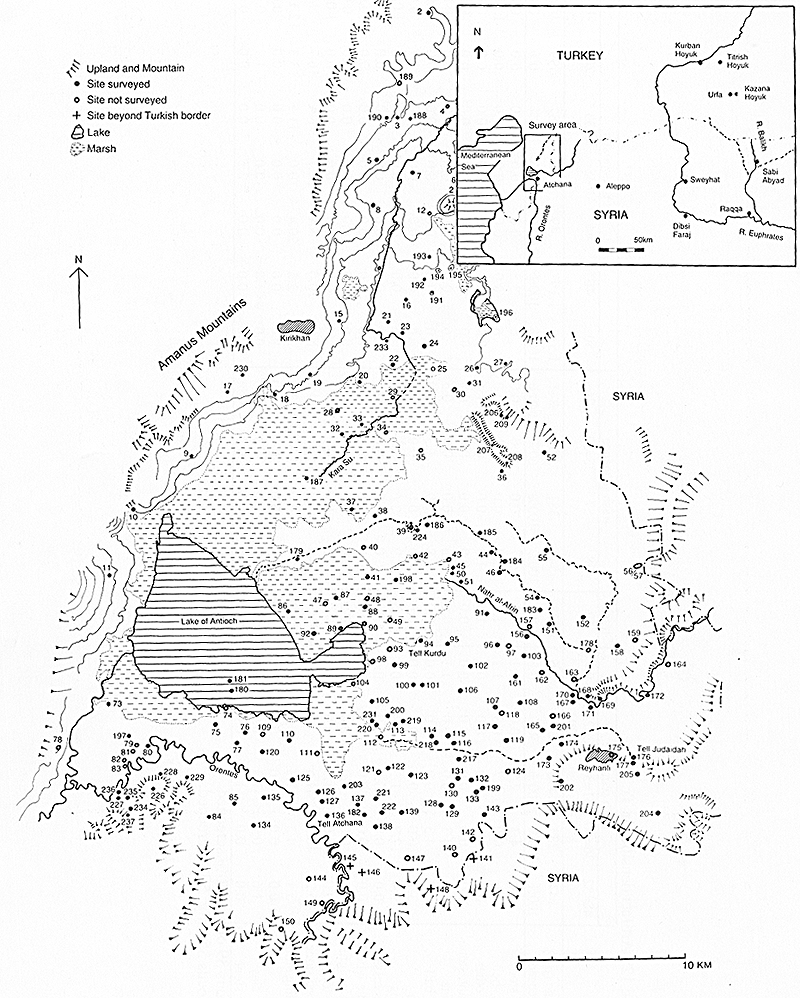
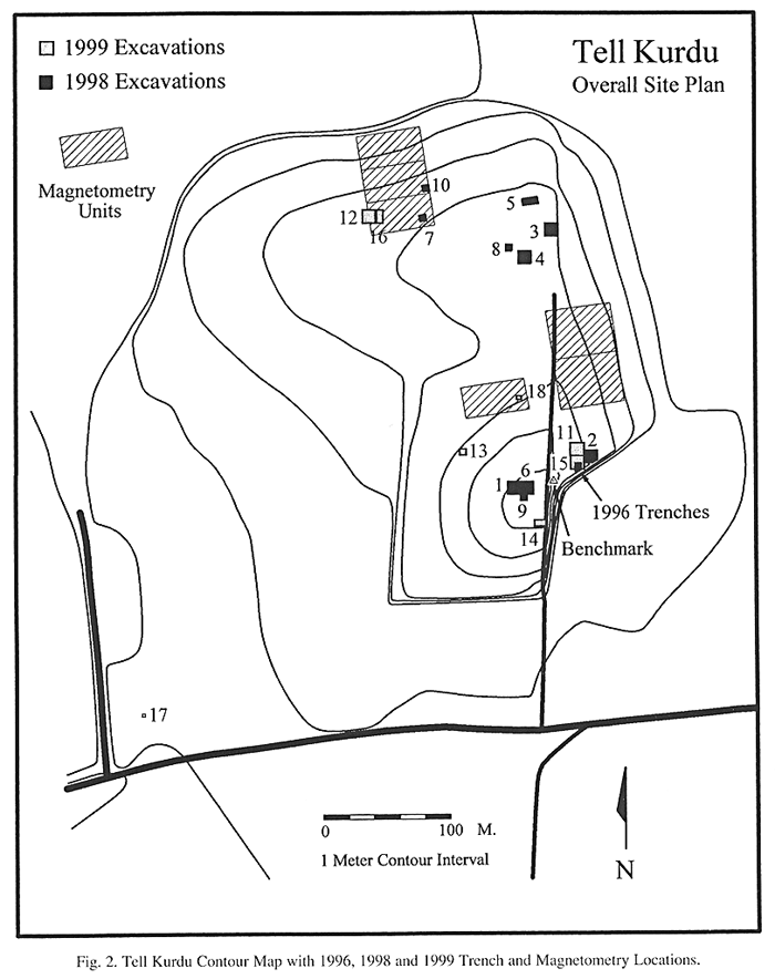
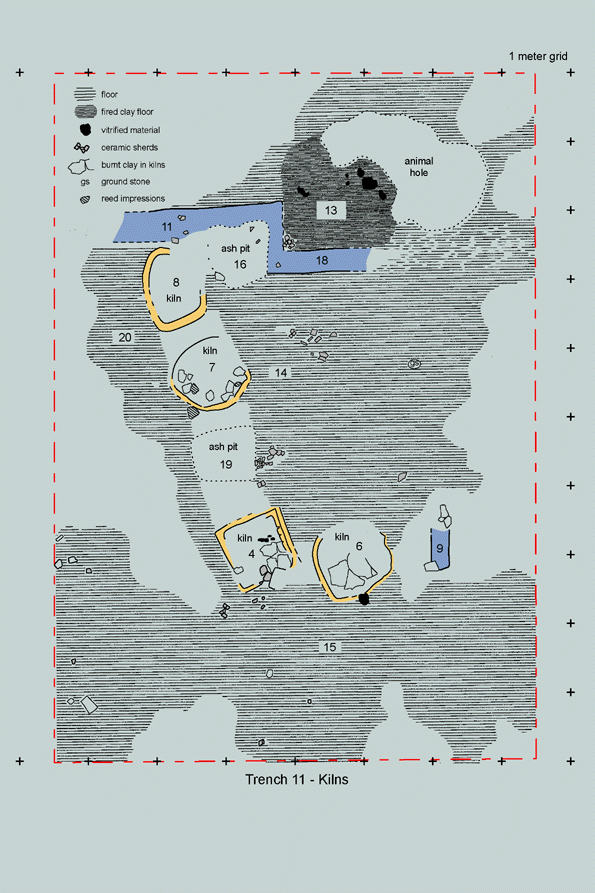
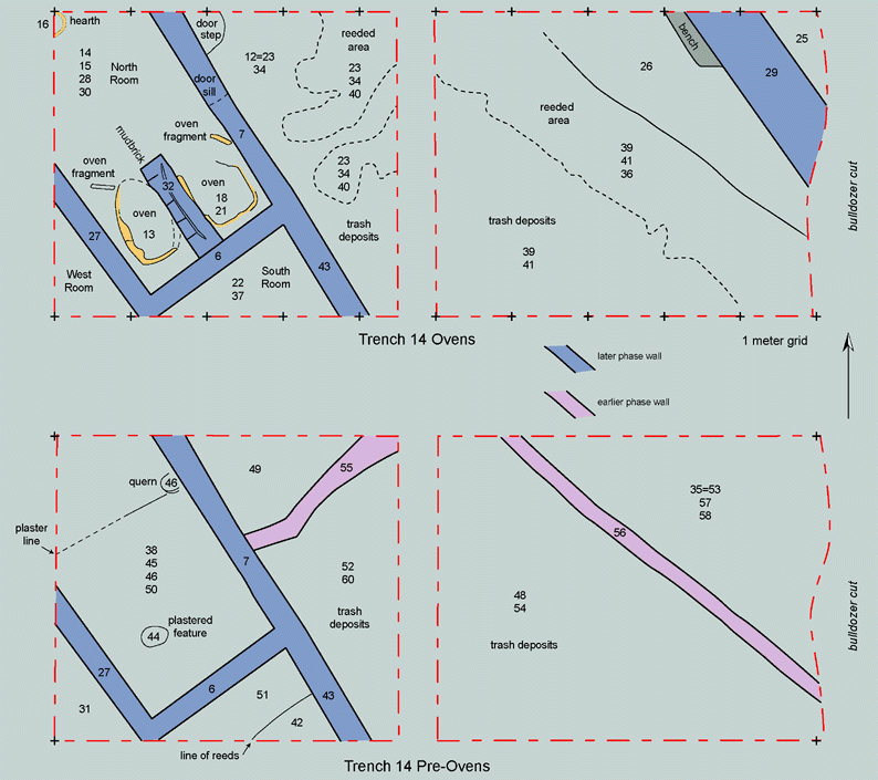
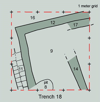
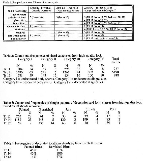
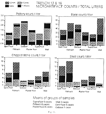
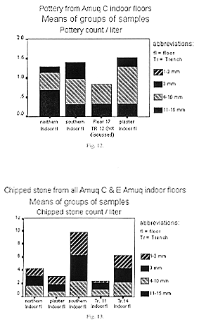
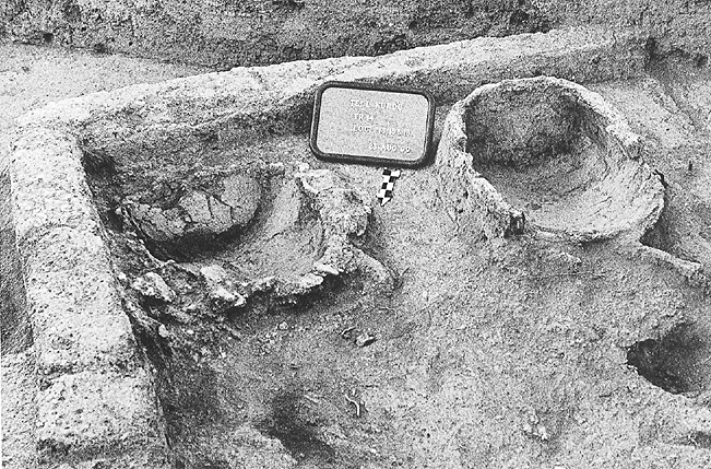
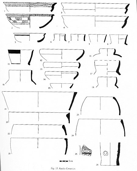
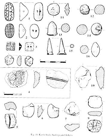
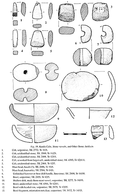
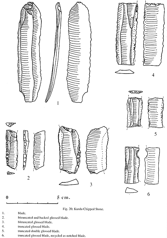